April 11 quake caused by a strike-slip fault
Besides the subduction zone (where the Indian plate dives under the
Burmese plate) that lies to the West of Indonesia, the Indian Ocean has
a diffused seismicity zone. This zone lies to the West of the subduction
zone.
The East-West trending zone extends from 80 degree East longitude to
around 93 degree East longitude (where the April 11, 2012 quake
occurred). The length of the zone is around 1,300 km.
 There have been seven major earthquakes between 6 and 7.5 magnitude
in this region during the last 25 years. The 8.6 magnitude quake of
April 11 and the aftershock of 8.2 magnitude should now be added to this
list. There have been seven major earthquakes between 6 and 7.5 magnitude
in this region during the last 25 years. The 8.6 magnitude quake of
April 11 and the aftershock of 8.2 magnitude should now be added to this
list.
The April 11 quake was not in the subduction zone but to the West of
it. “It is an intra-plate earthquake,” R.K. Chadha, Chief Scientist at
the National Geophysical Research Institute (NGRI), Hyderabad, told The
Hindu. An earthquake is called intra-plate when it occurs within the
plate and not at the edges of two plates.
Since it is an intra-plate earthquake, no subduction takes place and
the fracturing causes a strike-slip fault - where one edge of the plate
grinds past the other horizontally. The diffused seismicity zone has an
East-West direction. This zone could have formed as a result of westward
transfer of stress from the subduction zone. “The April 11 earthquake
was about 100 km West of the subduction zone,” he said. “It is within
the Indo-Australian plate.” According to him, the movement of this plate
(at a rate of 52 mm per year in a NNE direction) in the diffused zone of
seismicity is governed by mid-ocean ridges in the Indian Ocean. There
are two ridges there - Southeast Indian Ocean ridge and the South Indian
Ocean ridge.
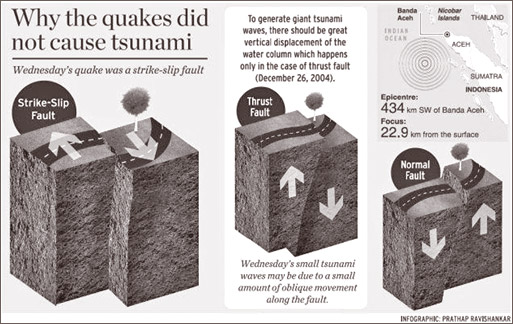
Why there was no tsunami
The US Geological Survey (USGS) initially estimated the April 11
earthquake off the west coast of Northern Sumatra, at 8.9 magnitude. But
it was subsequently lowered to 8.7 and then to 8.6. Similarly, the focus
of the quake was first thought to be 33 km from the surface, but was
later changed to 22.9 km.
The signals from a high-magnitude quake flood the nearby earthquake
recording station, leading to an initial estimation of high magnitude.
Explaining why tremors were felt in several Indian cities, R.K.
Chadha, Chief Scientist at the National Geophysical Research Institute (NGRI),
Hyderabad, said: “Tremors are felt at faraway locations due to surface
waves produced by an earthquake. Surface waves cause a lateral movement
of the particles in the earth’s medium. The earth behaves like an
elastic medium when seismic waves are travelling.” Unlike the December
26, 2004 quake caused by a thrust fault, Wednesday’s quake was caused by
a strike-slip fault. The fault had moved in a north northwest-south
southeast direction. In the case of a strike-slip fault, the fractured
crust slides past each other laterally.
“The movement along the fault should be in the order of a few metres,”
said Dr. Chadha. “Only a detailed modelling using data from 40-50
stations can reveal the actual amount of displacement.”
The reason why the 8.6-magnitude quake did not cause killer tsunami
waves was the nature of the faulting. “To generate giant tsunami waves,
there should be great vertical displacement of the water column,” Dr.
Chadha said. “This happens only in the case of a thrust fault (the
December 2004 quake) or a dip-slip fault. Strike-slip fault will not
generate tsunami waves.”
According to him, though the quake was a strike-slip fault, there
should have been a small amount of oblique movement along the fault.
This is the reason why Wednesday’s quake caused small tsunami waves.
Even the 7.2-magnitude quake of January 10, 2012, at a depth of 20.5
km from the surface off the west coast of northern Sumatra, was due to
strike-slip faulting.
Courtesy: The Hindu |


")


