From footpaths to expressways
Janaka Perera
Expediting the completion of expressways is
among the Government’s highest priorities. But to review the slow
progress made in this area until 2005 we need to go back in time
Until a couple of years ago conditions of our main roads were not far
different from what they were in the 1960s owing to the increasing
volume of vehicular traffic. Sri Lanka incurred an annual loss of around
Rs. 200 billion due to faulty road systems, a survey conducted by the
Moratuwa University a few years ago revealed. This problem however will
not disappear until the planned network of expressways linking the
country’s major towns and cities are completed.
Ancient road network
How did our grandparents and their elders cope with the poor
road-network? To begin with they did not face the transport difficulties
we face today.
There were four very good reasons for this: life moved at a much
lower pace and people traveled less, there was an excellent railway
system that almost never hampered by work stoppages or strikes, there
was far less vehicular traffic on the highways and towns were less
congested.
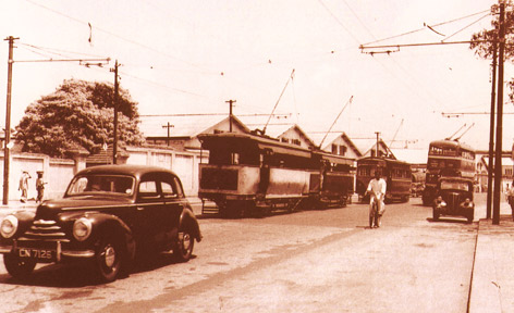 |
|
Colombo
roads experience much less trafic congestion before 1950.
ANCL file photo |
In the very early part of the last century, the Galle-Colombo road -
say from Moratuwa to Pettah - was half the width of what the same
stretch is today.
There were no motor vehicles in Sri Lanka and most parts of the world
until the beginning of the 20th Century since the first petrol-driven
automobile was invented only in 1885. Although the Dutch (1658-1796)
constructed a road network encircling the island’s coastal belt the
country’s most important road - the Colombo-Kandy highway - was built
only after the Kandyan Kingdom fell to the British.
But around 2000 years ago, at the peak of the ancient Sinhala
civilization, our kings did construct some excellent roads and mileposts
some of which were discovered in Anuradhapura and Polonnaruwa. These
however were built long before Sri Lanka’s encounter with the Western
powers and the subsequent establishment of the Kandyan kingdom.
Following the European occupation of the maritime provinces the
Kandyan Kings did not allow the building of any roadways linking the
hill country with low lands for a good reason.
The non-existence of a road network made it extremely difficult for
the foreign forces occupying the coastal areas to reach the hill
capital.
The jungle bordering the kingdom was kept thick and only footpaths
were allowed to penetrate it.
This environment was ideal for waging guerilla warfare against any
invader.
The policy made good dividends in an age when ox caravans horse-back
and palanquins were the principle means of transport.
At the time it took as long as 10 days to reach Kandy along the
cart-track-cum-foot path from Colombo whereas today it is a matter of
two-and-a-half-hour journey by motor vehicle or train.
The new expressway under construction once completed in 2014 is
expected to cut travel time between Colombo and the Kandy, from two
hours 45 minutes to a mere 55 minutes.
Roads for military purpose
When the British decided to clearing the jungle and build a roadway
it was primarily for military purposes rather than for public use. Later
with the dawn of the coffee era the road began to serve commercial
objectives as well.
The credit for the construction of the Colombo-Kandy road goes to
Governor Sir Edward Barnes who assumed office in 1820.
While the first sod was cut in 1820 and the trail was completed in
1821, the road was not open to traffic until 1825. Even then it had a
few culverts and bridges that were not completed until 1833 and the
metalling was not begun until 1841.
Another military officer, Major Skinner was appointed to build a
portion of the Kandy Road from Ampitiya to Warakapola, just above the
half-way mark.
He noted in his diary that the natives with whom he worked were
“totally unskilled labourers who had never seen a yard of made road in
the country, for the best of reasons that such a thing did not exist.”
An uphill task
Building the road to the hill country literally became an uphill task
since every night wild elephants broke down the embankments. In
addition, marshes, quagmires, swamps, pools and puddles posed a major
challenge to the engineers and workers. But completed, the road enabled
travelers to get to Kandy within a day by horse-drawn carriage.
The Gordon Bridge across the Hingula Oya was completed in 1822 and a
few other minor bridges too came up by 1825. Two other important bridges
- one across the Maha Oya at Mawanella and the other across the Mahaweli
Ganga at Peradeniya were both completed in 1832.
This was designed on the instructions of Lt General John Frazer based
on the wedge bridge system. The bridge was constructed in Colombo and on
completion transported to Peradeniya where it was erected by Captain A.
Brown without a single nut or bolt of any kind!
This too withstood all the traffic for 72 long years until an iron
structure replaced it in 1905. A model of this satin-wood bridge was
taken to be exhibited permanently in the South Kensington Museum in
London.
After the Kandy Road was opened to the public, toll points (a modern
day feature in developed countries) were established at the bridge of
boats at Grandpass, Atulugama, Ambepussa Bridge, Anguruwella,
Kadugannawa Pass and the Peradeniya Bridge.
The Colombo-Kandy Road ended the hill capital’s virtual isolation
from the rest of the country. It also brought a new source of revenue to
the colonial Government as well as immense wealth to several hundred
entrepreneurs with the opening up of land for coffee cultivation, soon
afterwards.
Old and new modes
The dawn of the motor vehicle era, saw a mixture of both old and new
modes of transport on the Colombo-Kandy Road as elsewhere. These
included what we today call ‘old crocks’ or vintage cars and buses with
rubber (bulb) horns, long footboards and cranks (used for starting the
engine), bullock carts, horse-drawn carriages and ox-drawn buggies.
Lake House was among the companies that operated a Colombo-Kandy bus
service beginning in the 1920s. Horse drawn carriages continued to ply
on our roads till late 1930s.
The length of the island’s road network today is about 92,700 km. The
roads linking the provinces belong to the A class while those connecting
the districts belong to B class. These roads are 11,600 km in total
length. The roads belong to the C, D and E categories are 16,500 km long
and unclassified roads are 64,000 km.
New challenges - however - are bound to occur with the completion of
expressways. The problem is that neither the police nor the emergency
rescue services, pedestrians and local residents, are fully aware of
road safety issues linked to super highways of this type.
The new expressways will require new facilities such as emergency
phones at regular intervals to alert traffic police and emergency
services. New regulations would also be necessary to facilitate the use
of seat belts, speed control in designated lanes and the halting of
vehicles.
|


")


