|
Tsunami Early Warning System:
Vital need for Indian Ocean countries
The German-Indonesian Tsunami Early Warning System for the Indian
Ocean (GITEWS) is on track. Main milestones like the development of the
automatic data processing software SeisComP3, as well as the underwater
communication for the transmission of the pressure data from the ocean
floor to a warning centre are already finalised.
|
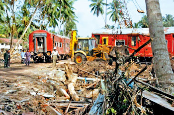
The train engulfed by tsunami waves in Peraliya, killing 1,500
people |
Furthermore the calculations of the ocean modelling including the
source modelling were completed and are available in a data base so that
the system can be set into operation at the end of 2008. This positive
conclusion is drawn by the GITEWS consortium consisting of different
German geo and marine scientists on the occasion of the third
anniversary of the tsunami catastrophe on December 26, 2004.
After the severe earthquake, where almost a quarter of a million
people lost their lives, the German government requested the Helmholtz
Association of National Research Centres, represented by the
GeoForschungsZentrum Potsdam (GFZ, Germany's National Lab for
Geosciences) to develop a tsunami early warning system. Already three
weeks after the natural disaster a task group headed by the GFZ
submitted a concept for GITEWS to the German government.
This concept is based on different kinds of sensor systems on land
and on the ocean and goes along with an intensive education and training
programme.
"The GFZ is working in Southeast Asia since 1992 so these broad
geoscientific results could flow into the proposal in a quick reaction"
explains Professor Reinhard, chair of the executive board of the GFZ.
"We would also like to establish this warning system in other
endangered regions, such as in the Mediterranean and in the Atlantic."
The tsunami early warning system is financed with 45 Mio. euros by
the Federal German Ministry for Science and Education and come from the
500 Mio. euro budget of the German Federal Government for reconstruction
activities in the tsunami region.
Seismological components
A tsunami is caused by a submarine earthquake. The quake in December
2004 had magnitude of 9.3, the second largest ever detected rupture in
the Earth's crust. A fast and correct seismological recording and
evaluation is therefore essential for the warning system.
The biggest challenge is the failure-free recording and the exact
quantification of strong quakes close to the epicentre. With the seismic
sensors installed so far in Indonesia and with the GFZ developed
software system SeisComP3 which was launched in May 2007, there is now
for the first time a tool to quickly register and evaluate even strong
earthquakes.
Its capacity and functionality has been demonstrated several times:
the magnitude of 8.0 and the location of the Bengkulu quake in the
southern part of Sumatra on September 12, 2007 could be determined
within four minutes. Based on that information the Geophysical Survey in
Jakarta (BMG) released a tsunami warning based on these data for the
first time.
Meanwhile SeisComP3 is established as standard in several states
bordering the Indian Ocean such as in the Indian tsunami warning centre.
The tsunami warning centre for the Mediterranean and the North
Atlantic will also go into service in 2008 with this software. "With the
software technical and methodical development within GITEWS we set new
standards not only specifically for earthquake monitoring but also for
the tsunami warning" said Dr. Winfried Hanka, project leader for the
GITEWS earthquake monitoring at the GFZ.
Oceanographic components
Based only on seismological measurements it is impossible to decide
whether a tsunami has arisen or not. Therefore the detection of a
tsunami is carried out directly on the ocean floor using oceanographic
instruments.
These measurements are also important to give the all-clear, because
not every earthquake generates a tsunami. This additional information is
very important for Indonesia, because earthquakes are easily sensible at
the coast and could give rise to panic reactions.
So a warning and an all-clear warning respectively need to be given
very fast. To meet these expectations different components are
established in the GITEWS concept.
Buoy systems
The final system will consist of 10 buoys, which will be deployed
along the Sunda arch off the Indonesian coast. The buoys have two
functions: they work as a relay station for the data of the underwater
pressure sensors (OBU - ocean bottom unit) transmitting their data from
the sea floor to a modem close to the water surface and from there via
the satellite connection of the buoy to a warning centre.
Furthermore the buoy has different sensors to determine meteo data
and the sea swell. But the pioneering aspect of the buoys is the GPS
functionality: through GPS measurements it is also possible to detect a
tsunami independent of the measuring instruments on the ocean floor.
This is an important progress compared to other buoy systems used for
example in the Pacific Ocean. The combination of underwater and surface
measurements guarantees a higher availability and less breakdowns.
Dr Tilo Sch"ne, GFZ Potsdam, leader of the GPS buoy working group as
well as of the tide gauges working group announced: "Based on the
experiences made with two test systems in Indonesia eight more systems
will be prepared and deployed in summer 2008 along the coastline of
Sumatra and Java. These buoys will be important components for the early
warning system."
Ocean bottom units (OBUs)
To recognise water pressure changes caused by tsunami waves, ocean
bottom units are installed on the ocean floor. In addition to this
standard measuring method GITEWS uses specific seismometers to detect an
earthquake directly on the sea floor.
The challenge is not only the measurement but also the transmission
of the data through the 4 km large water column. The first tests with
commercial modems did not fulfil the technical requirements because
transmitting the signal in thermally and salinary layered ocean water
through more than four kilometres is not trivial.
In co-operation with small and midsize enterprises it was possible to
develop a new transmission technology.
"The so-called PACT bottom pressure system (Pressure based
acoustically coupled Tsunami detector) is used for the real-time
detection of sea level changes in the deep ocean. In November 2007, the
PACT system successfully passed a deep-sea test close to the Canaries"
emphasises Dr. Olaf Boebel, PACT project leader from the Alfred-Wegener
Institute for Marine and Polar Sciences.
Tide gauge measurements
In deep water a tsunami propagates with the same speed as an
aircraft. But in shallow water the tsunami wave looses its speed and
gains height - up to 30 meters - close to the coastline.
Therefore, it is important to register a tsunami in suitable regions
e.g. offshore islands. Meanwhile seven GITEWS tide gauges have been
installed in the Indian Ocean, not only in Indonesia, but also in
riparian states. Reliable tide gauges data are available from South
Africa (Marian Island), Yemen (Aden) and Iran (Chabahar).
"Tide gauges measurements allow for a reliable prognosis if a tsunami
wave is expected and in which dimension. So it is possible to receive
detailed information of the inundation, which is especially of
importance for densely populated areas such as Padang".
Tsunami-simulations are of particular importance for the whole
warning process. Based on a few measured data an overall picture has to
be calculated. A couple of minutes after the earthquake the modelling
results will give an estimation on the wave height, the time of arrival
and the inundation areas.
Combined with the information on the settlement structure in affected
coastal stretches this is valuable information for the authorities and
the population. Since warning times in Indonesia are extremely short,
thousands of different scenarios are pre-calculated.
According to measured event data the best-fit scenarios are selected
from this data base which comprise all the necessary data like arrival
time, wave height and risk evaluation. This assessment of the situation
will be continuously improved taking more and more measured data into
consideration.
The data gained from this simulation also provides the basis for the
alarm of remote areas threatened by the tsunami such as India, Sri Lanka
or East Africa.
"The concurrent utilisation and analysis of all available data allows
- for the first time - a precise prediction of the inundation in the
influenced regions in an extremely short time scale.
TsunAWI, the new tsunami simulation software based upon calculations
on unstructured triangle grids which was developed at AWI and the
innovated GFZ modelling of the earth crust deformation/movement, are the
basis for this new achievement" underlines Dr. J Behrens coordinator of
the GITEWS simulation group.
The Warning Centre
The core of the early warning system is the warning centre. All
sensor data converge here, from here all the instruments are controlled,
and here the synthesis of all data and the pre-calculated simulations is
done and the alarm is given.
These different activities are integrated in a decision support
centre (DSS), which provides the responsible officer with an overview of
the available data, an assessment of the situation and proposals for
decision.
This system, seen from the viewpoint of conceptual design and
complexity, is unique worldwide. The development of the DSS is done by
the German Aerospace Centre (DLR) and is in good progress. At the
beginning of 2008 the first prototype will be installed in Indonesia.
Civil defence, Education and Training programme
The fastest warning is useless as long as the gap to the so called
"last mile to the beach" is not closed. The population in the threatened
area needs to be informed in time, but they also need to be trained how
to react properly.
The people need to be informed about evacuation plans and how to
behave in a case of emergency. Japan carries out this kind of training
in schools, plants and companies on a regular basis. The establishment
of such an education programme in the areas bordering the Indian Ocean
has only just started.
The Hindu
|