|
 |
| Thursday, 06 January 2005 |
 |
|
| Features |
| News Business Features Editorial Security Politics World Letters Sports Obituaries
|
Mechanics of the tsunami disaster by Professor Ananda Gunatilaka December 26, 2004 will forever be etched in the country's history and
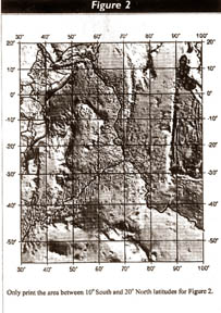
in the psyche of our people. It is probably the greatest The cost in terms of lives lost, trauma, social dislocation and material destruction is incalculable. The disaster was caused by Tsunami (is both singular and plural.) - a Japanese term meaning "harbour wave", which is NOT a tidal wave. Tsunami are earthquake generated giant ocean waves. Watching the news broadcasts I was reminded of a dramatic painting titled "Beneath the Waves off Kanagawa" by the great Japanese artist Katushika Hokusai (1760-1849) depicting the helplessness of a group of boatsmen in the face of tsunami-sized ocean waves. Tsunami can move at over 800 km per hour and are frequently more than 25 metres high when they reach a coastline and crash over. In 1958, an avalanche that landed in Lituya Bay, Alaska, created the largest recorded tsunami (524 metres high), bigger than the tallest building on Earth. In Sri Lanka, these waves rarely exceeded 12-15 metres, yet the resulting damage and loss of life were catastrophic. I am not an aftermath expert. But in a country where science is of very low priority, to educate the public with the science behind such disasters is, I feel timely. The Tsunami What is the geology and mechanics behind these catastrophic waves? Most tsunami originate from a large and instantaneous displacement of the sea floor during submarine faulting, either when the sea floor drops down as a block, rises as a block or as a thrust during a major earth-quake. In the former case, a trough in the ocean surface results, temporarily withdrawing water from the coast. A wave is created as the water rushes in to fill the trough, overcompensates, and travels to land as a catastrophic crest - a tsunami. When a part of the sea floor is trust upward, water is displaced upward, pulling along a vast volume of water from the shore, which soon returns to the coastlines as tsunami.
They are generally undetected before they strike a coastline thousands of kilometres away. At sea, the tsunami is hardly observable or perceptible. With crests of successive waves (the wavelengths) separated by as much as 160 km, these waves therefore are mere humps on the sea surface. Fishing boats would ride the wave, not knowing a tsunami is moving under them. Consequently, a tsunami becomes visibly only in the shallower waters of coastline, harbours and bays, where the friction and drag against the sea floor causes the fast moving waves to bunch up as devastating high walls of water - a frightening sight to behold as was depicted by Hokusai and seen by thousands of victims over the ages. In 1960, a 9.5 M earthquake in Chile generated a tsunami that travelled 17,000 km and hit Japan 22 hours later. If after shocks of sufficient magnitude occur and causes further displacements on the sea floor, then a series of tsunami may follow, causing further destruction. But this is not common. Additionally, seismic waves cause the water in enclosed bays, harbours or lakes to move back and forth rapidly across a basin, rising and falling. This phenomenon is called a seiche and can develop at great distances from a quake epicentre. It is possible that seiche waves also compounded the destruction caused in some bay areas of the southern coast. It is a misconception to believe that all tsunami are caused by earthquakes. This is furthest from the truth. In fact, there is a class of tsunami that is totally unrelated to seismic activity and earthquakes. These are the massive submarine sediment slides (or undersea avalanches) generated within continental slopes due to slope and sediment instability, massive landslides or avalanches that end in the oceans (called mass-movement events), large meteorite (bolide) impacts and violent volcanic eruptions. Even a slight tremor can trigger off a submarine slide. These have also occurred throughout geologic history. The huge sediment masses in motion will displace a massive volume of water to generate destructive tsunami. The tsunami generated by the massive explosion of Krakatoa volcano in the straits between Java and Sumatra (in 1883) reached 40 metres in height and drowned 36,000 people on nearby coasts. It is possible that its effect was felt in Sri Lanka within hours of the eruption, although no records are available. Alternatively, not every submarine earthquake will generate tsunami. Just ten days ago, an 8.1m earthquake occurred between Tasmania and Antarctica, but no destruction was caused. Waiting for the next great seismic shock and accompanying tsunami only is not good enough, as huge sediment slides, meteorite impacts and violent volcanic eruptions in the nearby ocean can also do great damage by generating large ocean waves. Spokesmen (who give expert opinions) had better be aware of these facts. The 9.0 M earthquake (Richter Scale) that generated the tsunami, which struck the shorelines of the southern Indian Ocean (mainly Sri Lanka and Tamil Nadu), Thailand, Sumatra (Aceh Province) and even extended to Somalia in East Africa, originated offshore of northern Sumatra (the large star in Figure I) is probably the second highest ever recorded in the sea. The Sumatra area is known for its recurrent earthquake activity as it is the boundary where major tectonic plates interact. This boundary called Subduction Zone is represented bathymetrically by the curved Sunda Trench, a long fault plane and a nearby volcanic arc, where the north-east moving sea floor (at ~6 cm per year) of the Indian Plate is thrust under the adjacent and smaller, overriding Burma Micro-Plate. Strain builds up in the subduction zone, until the 'frictional lock' in the rocks is broken at the focus and a rupture occurs. This initial rupture spreads over a section of the long fault, producing rock deformation. An earthquake occurs when rocks being deformed suddenly break along the fault, releasing long accumulated stresses. The blocks of rock on either side of the fault slip suddenly, setting off ground vibrations. Slippage is most common along plate boundaries. The aftershocks suggest that the rupture had a maximum length of 1200 km parallel to the Sunda Trench and a width of over 100 km perpendicular to the earthquake source. Much of the slip was apparently in the southernmost 400 km of the rupture, i.e. in the Sumatra sector. The amount of vertical displacement of the two fault blocks is the slip, which was ~20 metres. The maximum displacement of the sea floor was about 10 metres to the W-SW and was uplifted by several metres. The Sunda Trench (the second largest after the Peru-Chile Trench) is up to 7.5 km deep. The earthquake foci down an inclined subduction zone can extend to depths of up to 700 km in the mantle. However, it is shallow focus quakes like the recent one in Sumatra (only 30 km below the sea floor) that are most destructive. The physical measurements of slip and displacements are by courtesy of the USGS National Earthquake Information Center. They indicate the awesome magnitude of the whole event. Crust Briefly, over 1,000 km of the Earth's crust just 30 km beneath the sea floor snapped, moving the Burma Plate ~13 metres over the underthrusting Indian Plate. The thrusting rapidly raised the sea floor, generating the tsunami that devastated coastlines of the southern Bay of Bengal. Phuket Island in the Malacca Straits is to the northeast of the epicentre. This detailed picture shows why Phuket, the Andaman and Nicobar Islands were also destroyed. Sumatra (Aceh) had no chance at all, being right on the margins of the tectonic plates, with 80,000 dead already. It was all too close to the epicentre and the accompanying tsunami. A series of violent after shocks have followed the main quake (Fig. 2). One measuring 6.5 m in Sumatra on New Year's day was perhaps the largest, but caused no damage or tsunami. These shocks are an indicator of the readjustment in tectonic stresses still going on within the fault zone. Epicentre The distance between the epicentre (the surface expression of the focus) of the quake in Sumatra and Sri Lanka is ~1500 km or ~12 degrees longitude (see Fig. 2). The quake occurred at 6.58 a.m. (Sri Lanka time), at 8.35 a.m. the Ampara coast was hit by the tsunami and the rest of the coastline soon after. With some minutes taken for seismic analysis by the recording centres and issuance of a warning (by whom? and to whom?) to the surrounding countries (with uninformed and lethargic bureaucracies), about 70 minutes would be available for evasive action - an impossible situation. Without an early warning system in the Indian Ocean (unlike in the tsunami prone Pacific Ocean), we simply had no chance of escape. Further, there was no history of tsunami in this part of the Indian Ocean and hence the need to educate the public had not arisen. The stage was set for a major disaster, whose surreal effects are now there for all to see. Over 25,000 dead and rising, over a million people displaced and drastic damage to property and infrastructure facilities. The power of flowing water was depicted in dramatic fashion - buses and trucks tossing around like match boxes, train carriages ripped off their chassis, rail lines twisted and ripped off their tracks, with over 850 people losing their lives within minutes in a train near Telwatte (my late father's village). The 1500 km of open and Deep Ocean in the Bay of Bengal provided enough fetch for the ocean waves to build up momentum, forming a massive wall of high water on the coastlines, as the sea bottom shallowed. Its effects even reached the coast of Somalia in East Africa causing significant damage there. By now, the waves would have traversed the global ocean, dissipating and eventually dying out. Energy The initial energy release of the Sumatra quake is estimated at -2 x 10¹⁹ m.ergs (= to about 25 Hiroshima bombs). Much of the energy of the tsunami is conserved during its travel in deep water and is then suddenly released when reaching shallow water, causing the enormous destruction along coasts. Most waves do not exactly break on the shore as a large wall of water, but rather continues inland as a fast stream of high water (like a tidal bore) swallowing everything in its path. Such a situation may have occurred in the Mullaitivu area in N-E Sri Lanka, where the sea water column reportedly extended up to 5 km inland from the coast. In many areas of Sri Lanka, the walls of water were up to 10 metres high when they lashed against the shoreline. Eventually, the death toll might exceed 30,000. It is truly a global scale disaster as people from many countries were affected (nearly 150,000 dead so far). Nature is truly a great leveler and must be treated with respect. Publicity Sadly, this disaster was made use of by some spokesmen and outright scientific fraudsters for personal publicity. An irresponsible TV-channel interviewed one man who claimed to be a geologist that he had predicted this region-wide calamity months ago, based on his research of soil and water samples in Sri Lanka. He said that his current research is incomplete, but confidently predicted another similar disaster next year. He mentioned of earthquakes in Wellawatte and Moratuwa on that fateful day as the cause for destruction. In my 40-year career as a geologist, I had never come across such baloney. He had made similar pronouncements before when landslides and floods affected Sri Lanka. No doubt the gullible will panic at some future date when another prediction is made. This TV-channel should be reprimanded severely and soon. Another person said to the newspapers that he can give warnings of a coming tsunami within 90 minutes of its reaching Sri Lanka (sans an early warning system?). We do not have any authentic evidence of a tsunami having occurred 21 centuries ago in Sri Lanka. The description in the Mahawansa cannot be considered as proof or interpreted as such for the authenticity of such an event. It is too vague, but I stand to be corrected. Why go so far back in time? A better bet would be to refer to the English newspapers of then Ceylon for any reporting of the August 28th 1883 Krakatao volcanic eruption in Indonesia, which caused a tsunami of great destruction and whose effects must have been felt in Sri Lanka (we had newspapers published here in 1880). A large quake had also occurred in Sumatra in 1832. As a recent editorial said, we would rather believe predictions of astrologers and planetary position experts in relation to our times and dates of birth. They predicted neither 9/11 nor 26/12. We cannot even manage lesser disasters such as floods, landslides and droughts. As always we will react to the situation. Task Forces are really bureaucratic overkill, which do not address the practical problems. Have we yet got a proactive programme in place when the next flood disaster strikes Sri Lanka? I am told that there was a Ministry of Disaster Management sometime back, which made no impact at all. Tsunami are a rare and "once in a century occurrence" in the Indian Ocean. There is evidence that US scientists have been tracking this last tsunami and trying to warn the countries of the region. But the warnings did not get through to the proper channels here. Also, it was the day after X'mas and a Poya Day and it was too early in the morning on a holiday to take things seriously. What if it occurred during a rainy night? Undoubtedly, more would have perished. Typically, we will now react by trying to acquire an expensive early warning system, which will cost millions of dollars (and we may not have tsunami for another hundred years). This should not be the immediate priority. This can come later as a regional effort and personnel to man the system need to be trained. Getting the infrastructure (railways, public transport, rehousing, roads, power, communications, water supply, public health etc) in place and educating the public in what action to take if a similar disaster strikes again is more important and money better spent. A devastating tsunami struck Flores Island in Indonesia in 1992. This should have sounded a warning as it is in a tsunami zone. Yet, just 12 years later nearby Aceh was destroyed, with over 80,000 perishing. They too were not prepared! It is easy to preach after the calamity. But what can be learnt from this unique event? Firstly, we use our common sense and not panic. * If you live close to the coast and feel a strong tremor or have heard in the news of a strong earthquake having occurred in the Indian Ocean or in a nearby coastal region, be prepared to leave everything and move to higher ground without panicking. * Tsunami sometimes signal their arrival by a precursory rise and fall of coastal water. This occurred in Sri Lanka. This natural warming should be heeded. Move away to high ground as soon as possible. * People have lost their lives by going down to the beach to watch a tsunami. The first tsunami waves after hitting the coasts, almost immediately roll back with great force and undertow. A vast area of sea bottom (up to 300 metres according to witnesses last week) is suddenly exposed with fish and shells strewn all over. People run down to collect. The wave instantly returns with even greater force and it is all too late to runback. Don't make this mistake. * Tsunami are continuously tracked by weather centers across the world after an earthquake (such as NOA in the USA). A linkage should be established with these centers through the internet or phone lines and the progress of the impending disaster should be conveyed to responsible authorities here. If correctly done, we should have at least an hour to take evasive action and save lives. The Meteorology Department is an obvious focal point for this. * Local Emergency Organizations should be set up along the coastal towns to warn the people. How are these organizations to be informed of the coming wave? * Completely prohibit by law any new constructions within at least 100 metres of the coastline. If people or politicians violate the law, prosecute them severely. This should come as a Presidential Decree. It would also decrease the coastal pollution. * A massive reconstruction effort is sure to follow. This would require vast volumes of fine aggregate (SAND) for concrete and masonry, which is in severe short supply even now. Use this opportunity to shift over to sea sand for construction. The massive cleaning up operation and better construction standards will also beautify our coastline * This is a new opportunity for Sri Lanka in ever respect. Get our act together for better commitment, self discipline, higher standards and civic consciousness. We have been given another chance. Good and strong leadership is required. No more organized chaos! This writer has not experienced tsunami firsthand before, except routinely teaching about them to generations of undergraduates. The 26/12 tsunami was indeed a lesson to remember. He has experienced three earthquakes in his lifetime. Two of them were severe. One of them in the western Arabian Peninsula in 1982 killed 2,800 people. The second was in California in 1989 (Loma Prieta, 7.1M) which did massive damage to the infrastructure but not many lives were lost (65 perished). I was fortunate to actually witness the seismographs at the Department of Geological Sciences, University of California in Santa Barbara record this tremor, minutes after the quake hit Loma Prieta. The University Alarm System went off soon after and the earthquake drill commenced, which was well organized and time-tested. Occasionally, the alarm system went off in the buildings without warning to test the preparedness and response of staff and students to a potential quake. It worked quite well. everybody took this exercise seriously and acted professionally. It was one of the first things mentioned when I first arrived. I was very impressed. A program was in place if any danger was present and everyone knew exactly what to do. Being close to the famous San Andreas and related faults and with the expectation of a really "Big One" anytime, it was a serious affair. It was an object lesson I still value. Tsunami is a word unknown to most people in Sri Lanka. Now it will be a new word in our vocabulary. There is no excuse now to mistake it for an exotic Japanese dish. It is a geological phenomenon of awesome magnitude and devastating power. (The writer was Professor of Geology at the University of Kuwait in the Arabian Gulf and Professor and Chair of Earth Sciences at the University of Oman. He was sometime Visiting Research Professor at the Institute of Marine Sciences, University of California, Santa Barbara. Presently retired, he lives in Sri Lanka.) |
|
News | Business | Features
| Editorial | Security
Produced by Lake House |

 natural disaster
to strike Sri Lanka in recorded history. It was sudden and unexpected and
was over rather quickly, but its 'aftermath and repercussions will
reverberate for years to come.
natural disaster
to strike Sri Lanka in recorded history. It was sudden and unexpected and
was over rather quickly, but its 'aftermath and repercussions will
reverberate for years to come.
 They usually occur as several large ocean waves that may arrive at
irregular intervals at the opposite coasts from their point of origin at
the earthquake epicentre (-250 km west of Sumatra in the present case, as
shown in Figure 1).
They usually occur as several large ocean waves that may arrive at
irregular intervals at the opposite coasts from their point of origin at
the earthquake epicentre (-250 km west of Sumatra in the present case, as
shown in Figure 1).