Vahalkada Tank: ‘Gateway to the Palace’
Prof. W. I. Siriweera
Vahalkada is located in the North-Central Province about 20
kilometres North-East of Kabetigollewa. The region is accessible by a
seven kilometre long road through Kahatagollawa, a village on the
nineteenth kilometre post on the Kebetigollewa-Padaviya road. Vahalkada
can also be reached through a longer route from Horowpothana.
The beautiful reservoir at Vahalkada which is of great antiquity is
little known. It has not been identified previously with any ancient
reservoir but its construction, is generally attributed to King Mahasena.
The attribution is correct and it can be identified with Ciravapi or
Siri Valahassa Vapi of the chronicles, one of the 16 great reservoirs
built by Mahasena (274-301). The Mahavamsa refers to it as Valahassa
Vapi. After the original construction, it was enlarged by Aggabodhi II
(604-614) and renovated later on several occasions.
 The
name Vahalkada, means 'Gateway to the Palace'. The reservoir is unique
because there are quite a few high mountains on several of its sides.
The mountain ranges in almost all other reservoirs are fairly low in
height. The
name Vahalkada, means 'Gateway to the Palace'. The reservoir is unique
because there are quite a few high mountains on several of its sides.
The mountain ranges in almost all other reservoirs are fairly low in
height.
Topographical survey
The reservoir was initially re-discovered by H.C.P. Bell in 1891 but
Henry Parker has made an allusion to it as 'not a tank of great size'.
The initial topographical survey was done by Wickwar in 1898. In 1934, a
detailed description of the dilapidated and dysfunctional tank was
provided by R.L. Brohier in his seminal work 'Ancient Irrigation Works
in Ceylon'.
The reservoir has been constructed by erecting embankments in between
the hilly region known as Mahinna, which runs North-East and South-West
at a point known as Yakini Kanda, and the low Sandy ridge known as
Godahinna. The length of the artificial embankment is about three miles
and thousand feet.
The main supply source of the reservoir is Tavalam Halmllava Oya, a
tributary of the Yan Oya. Traces of a fairly wide ancient canal and a
diversion weir across the Mora Oya (feeder stream of the Padaviya tank)
seem to indicate that a part of the water of the Mora Oya was also
diverted to the Vahalkada catchment.
The ancient sluice consisted of two outlets and a tower of brickwork.
There had been no man-made spill or Vana at Vahalkada. The excess water
had passed through natural rock formations. The topography of the area
indicates that the purpose of the reservoir was agricultural irrigation
as well as domestic utilization.
Commercial centre
Just as Padaviya, Vahalkada also was a centre of long-distance and
regional trade from about the eighth century A.D. to the thirteenth
century. Incoming and outgoing commodities to and from the ports in the
North, North-West and East passed through Vahalkada. The Vahalkada Tamil
inscription datable to the first half of the twelfth century indicates
that the town was a centre of commerce where South Indian mercantile
communities were active. It refers to the Nanadesi Virapattinum, the
ancient Tamil name for Vahalkada. According to the inscription, Nanadesi
Virapattinam, established by the Ainnurruvar of the 'thousand
directions' declined due to some heavy indemnity or ransom payment made
to a certain Kuttiperuman. Kuttiperuman may have been a military chief
who ransacked the town. The state of anarchy and uncertainty which
prevailed in between the reigns of Vijayabahu I (1070-1111) and
Parakramabahu I (1153-1186) of Polonnaruwa provided the setting for
chiefs in various regions to exercise their authority through military
force.
The inscription also refers to the actions taken by the governing
council of the town to uplift the conditions of the commercial centre.
The council had decided to waive the taxes on shops in the streets of
the town in order to promote trade. From the titles and epithets of the
members of the governing council of the Pattinam, it can be gleaned that
the three most important professional categories of the town were
merchants, warriors and the administrative officers.
The term ‘akkacalai’ mentioned in the inscription is important. It
could designate a mint, an artisan manufactory, a community of artisans
or a locality occupied by artisans. Whatever the connotation is, it is
clear that Vahalkada apart from being a centre of agriculture and trade
was also a centre of craft production. The inscription further indicates
that there was a customs post set up within the limits of Vahalkada.
|
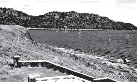
Vahalkada Tank. Picture courtesy: Panoramio.com |
Restoration work
Along with almost all other reservoirs in Rajarata, the Vahalkada
tank had been abandoned after the middle of the thirteenth century. The
decline of population and the expansion of the jungle hid this beautiful
reservoir from the eyes of civilization. In the course of centuries the
bund had been breached at the Mahinna ridge in the Eastern section and
the water passed through Tavalam Halmillava Oya to the Yan Oya. By the
time Bell, Parker, Wickwar and Brohier re-discovered the reservoir it
was covered with jungle and was in a state of disuse.
According to records available at the irrigation engineer’s office at
Padaviya, the Vahalkada reservoir had been restored only in 1973 at an
estimated cost of Rupees five million three hundred thousand. A further
five million one thousand three hundred and thirty three rupees had been
spent for providing amenities such as roads and settlement of colonists.
The restored reservoir covers an area of two thousand two hundred and
fifty seven acres and has a capacity of forty three thousand acre feet.
The height of the earth bund ranges from 35 feet to 50 feet. The ancient
sluice in the left embankment had been ignored in the restoration work
as there had been a leak in the sluice. A new sluice and a distributory
canal system has been constructed. After the restoration, one thousand
families from nearby Kunchuttu Korale have been settled in the Vahalkada
colonization scheme. Each of the families has been allocated two acres
of paddy land and one acre of highland.
Archaeological sites
The colonists have been provided with only agricultural implements
and planting material. The settlers have been accommodated in eight
plots; D (Distributory Canal) 1 to D8. D7 and D8 plots were allocated
only in 1993. In addition to paddy and chena cultivation, inland fishing
is a source of income in the area.
Several archaeological sites in and around Vahalkada testify to the
antiquity of the region. A village called Puhu Divula contains an
ancient ritual centre. Below the tank bund, there are traces of ancient
buildings.
A relocated sculptured figure of Bahirava and a Tamil slab
inscription can be seen near the plaque commemorating the inauguration
of the restored reservoir in 1973.Vahalkada sheds light not only on
irrigation and agriculture in ancient Sri Lanka, but also on the
urbanization process associated with large reservoirs. Places such as
these are also important localities for a study of the Dry Zone
colonization schemes in the post-independence Sri Lanka. |


")
