Flyovers as a traffic management measure
Osada Vishvajith Peiris
The performance of the recently introduced flyovers road
intersections can be tested by comparing before and after conditions in
relation to the overall expected achievements by using spatial
parameters. Basically, accident counts, speed and travel time surveys
can be used as the main evaluation criteria to test this at a particular
location.
Moreover, the variation of the pedestrian movement pattern, impacts
on the trading activities and vehicular flow pattern after the project
implementation can be used to evaluate the level of impact to the users
at the location which are hardly being considered in the traffic
engineering perspective in Sri Lanka.
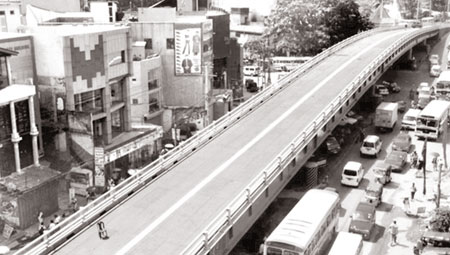
Flyovers are introduced to road intersections after originally
introduced to railway intersections such as Ragama, Kelaniya, Dematagoda
etc. A steel cantilever type flyover introduced to Galle road (A2) at
Dehiwala junction in 2009 to eliminate the traffic congestion which
caused many delays, accidents, pollution, etc.
Road intersections
Unlike railway intersections, turning movements are present as well
as through movements at road intersections.
So the flyover structure and design must support both types of
movements at the same time which is practically difficult to tackle in a
country like Sri Lanka. This situation is severe if there’s a transport
terminal is present in a nearby location such as Dehiwala.
Flyover at Dehiwala junction was the second flyover introduced to
road intersections along Galle Road after Nugegoda flyover along High
Level Road. Dehiwala has about 30,000 daily vehicular movements and the
flyover constructed within six months and completed by October 8, 2009.
Total cost of construction	Rs. 870,000,000
Length of the flyover		337 meters
Width of flyover		7.35 meters
Funding agency	British government
Construction companies	British firm
	 Mabay and Johnson Ltd.
	Access Engineering  Ltd.
Expected vehicular flow per day	40,000
in both directions
Date of Commencement	April 20, 2009
Date of Completion	October 8, 2009
Basic description of the flyover
Accident data
According to the collected secondary data, common feature at the
flyover was that there’s a significant increase of accidents at Dehiwala
after the flyover introduction.
Also, according to the figures, it can be seen that the sudden
increase of accidents had taken place after the flyover construction.
This was proved by the traffic Police Division and they had to allocate
15 more officers on duty near the flyover as it was only five before the
flyover came there.
The composition of accidents at Dehiwala after the flyover
construction is 67 percent on the flyover. Highest amount of accidents
were happened at the flyover and conflict at the intersection has been
comparatively minimized.
It can be concluded that flyover itself has caused rapid increase of
accidents and it failed to reduce the conflicts among vehicles as
expected so.
Commercial activities
Dehiwala town along the Galle Road has linear development mainly
dominated by commercial activities. According to DMMC records, Dehiwala-Mount
Lavinia is a densely populated town, where almost 75 percent of the area
has densities ranging from 100 to 150 persons per hectare and 64 percent
of the land is in residential use. The commercial and service sectors
are thus well developed to cater to a population of 209,787 persons
(2001).
With the introduction of flyover, the level of impact to the trading
activities was significant. The level of impact to the trading
activities located within and away from about 300 m distance from the
flyover was severe while it had lesser impacts to the commercial
activities away more than 500m. According to the survey findings, the
mega structure would create a visual disturbances as well as economic
prosperity of the junction.
This research was carried out to test the appropriateness of flyovers
in the urban road intersections as a traffic management measure. It is
revealed that the disadvantages of the flyover are comparatively higher
than its expected benefits. There are several flyover projects done in
Sri Lanka over the railway intersections as well as road intersections.
The performance of the flyovers at the road intersections are highly
criticized than over the railway crossings where additional vehicular
pressure was created due to the selective node.
But the trade-offs between the advantages and disadvantages can be
forecasted with the actual situation caused by the set up.
Dehiwala flyover had been constructed in 2009 and within 23 months of
performance, the direction of overall objectives can be measured in the
traffic management and land-use management perspectives.
Traffic management
There are multiple issues as well as benefits gained by the location
through this project. It was evaluated through travel time data
analysis, accident surveys and speed variation before and after
situations at the intersection.
It was observed that the sudden speed drops and increased accidents
related to the flyover. The apparent reasons observed are (a)
obstructive design of the flyover at the approach level which blocked
the visual path of the users (b) the lack of overtaking opportunities in
heavy traffic as there is only one lane of traffic in each direction.
Also the functional efficiency and the land use activity pattern which
really matters when transportation infrastructure provision were not
considered at all in these mega projects. Even the regional traffic
management which was considered as priority goals of the flyover project
were not met as design failures as well as miscalculation of priority
modes of travel at Dehiwala intersection.
One of the major limitations which I got to know in the research
study was the less co-ordination among relevant administrative bodies.
The shared responsibility between road development agencies, management
bodies as well as the local authority in pre and post assessment of the
performance of flyover at the location was not done properly. Similarly,
the relationship between the land use activities, function of the
location with the transportation modes, road users were not considered
by the implementing bodies. There were no pre feasibility studies or
feasibility studies found for the flyover project at Dehiwala
intersection which is a mandatory requirement at the standard context.
Few suggestions
Transportation infrastructure provision and land use pattern has a
close relationship which didn’t get any attention by the road engineers.
This resulted mismatch between expected outcomes from the flyover with
actual situation at the location. Therefore it can be recommended to
evaluate the land use compatibility with the transport system before
introducing costly traffic management tools such as flyovers.
Finally it can be concluded that the expected overall traffic
management objectives were not achieved by the flyover project at
Dehiwala and there are few suggestions by the users at the location
which proved by the calculations which can be effective solutions
compared with the existing condition at the junction. Basically the
functions at the intersection (transition, terminal, etc) and the road
geometry (gradient, width, road trace) has to be critically evaluated
before the decision making of flyover project. Also different traffic
management measures introduced in Sri Lanka could be compared with
flyovers in future interest.
This research study was conducted by the writer as a dissertation
thesis for three months (from January 2011 to March 2011) at Department
of Town and Country Planning under the supervision of Planner K D
Fernando, Senior Lecturer, Department of Town and Country Planning,
University of Moratuwa |


")

