Upstream before Downstream
Dr. T. S. B. Weerasekera Consultant and Snr
Specialist Officer (Land Use) Ministry of Irrigation and Water
Management
Some of the natural tribulations in the areas associated with the
lower part of rivers and streams often reflect inappropriate land use
and land use management in the upstream regions. Ironically, while the
highly populated and urbanized downstream regions depend on the water
supply and hydropower that originate in the upstream areas, they are
vulnerable to threats such as floods, polluted water, high electricity
costs or power cuts precipitated by low reservoir water levels, sea
water intrusion caused by low water levels of rivers, all posed fully or
partly by upstream land related activities.
|
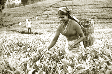
Plantation needs water as without it the trade that’s most
recognized will not be able to survive |
In countering the threats, protection measures are invariably
resorted to in the downstream regions at very high costs. Construction
of elaborate systems of flood bunds, intricate drainage systems that
include pumping, installation of fuel power plants to deal with any
shortage of power caused by low reservoir water levels, mechanisms for
the prevention of sea water intrusion are some examples.
Proper management of upstream regions would have saved a lot of money
and recurring disasters such as floods. However, little attention, if at
all, is directed to the cause. The management of upstream involves three
major components that are related to each other.
First is the introduction and maintenance of appropriate land use and
land use management in the upstream, regions supported by a strict set
of land use policies. The second is land conservation. Third is
harnessing the water.
Watershed
In the past five or six decades the land use in the upper watershed
regions in Sri Lanka has changed drastically for the worst. Reduced
forest cover, degradation of some of the tea plantations, a rapid
expansion of annual crop cultivation on steep slopes, are the most
prominent of the changes in land use that have taken place during that
period. The total effect of these changes is a very significant
reduction in the capacity of upstream lands to maintain a temporary
rainwater storage from which slow release of water to the streams will
occur. One of the main contributors to this situation is the lack of
sufficient amounts of structured foliage to intercept rain, resulting in
higher run off and low infiltration. The other contributor is the
reduced soil depth due to soil erosion in degraded tea lands, freshly
deforested areas, and lands with steep slopes that are used for
cultivation of annual crops.
At present, although there is a decrease in the rate of deforestation
in the upstream areas, the degradation of tea lands and cultivation of
annual crops on lands with steep slopes continue.
Large extent of degraded tea lands exist particularly in Nuwara Eliya,
Kandy, Ratnapura and Badulla Districts. These are characterized by
shallow soils, exposed rock, and tracts of tea lands with very low bush
density.
They show evidence of severe soil erosion that has taken place over a
long period. They come under the general land use category of abandoned
tea lands, because land degradation over the years due to soil erosion
has caused ever decreasing yields, and the consequent abandonment. It is
also evident that the process of land degradation continues in some of
the tea lands. Various stages of land degradation can be recognized by
decreased bush density, a high percentage of exposed soil and decreased
soil depth.
Management
Conservation of tea lands is part of tea land management. For
example, erosion control measures should be an essential component in
the set of agricultural inputs. It should be realized however, that high
costs involved in land conservation may make tea production less
profitable.
This is where the matter becomes a national issue. On the one hand
tea industry has to be protected.
On the other hand land conservation should be upheld as part and
parcel of appropriate land use and land use management of the upstream
areas.
Therefore, considering it as a national issue of high priority, the
state should grant the policy and financial support to the tea industry
for the conservation of tea lands.
Degraded tea lands and the tea lands that are susceptible to
degradation are two main areas that should be addressed by the state in
providing policy and financial support in promoting appropriate land use
and land use management aimed at conservation of land. Because degraded
tea lands can no longer support profitable tea cultivation, conservation
based alternative land use types that are somehow economically and
financially rewarding should be introduced to these areas.
The issue of tea lands that are susceptible to degradation is
somewhat complicated.
The degradation process may begin as a result of poor administration,
poor technical management, or both. Also, it may be initiated by a
sudden financial crisis precipitated by for example low tea prices, or a
severe yield reduction brought about by long drought conditions.
In this situation, there may be a breakdown in providing the standard
inputs necessary for the cultivation itself and for soil conservation
measures such as maintenance of terraces and stone bunds.
Whatever the reason that activates the degradation, if immediate
attention is not paid, the degradation process will continue until the
yield levels are low enough to justify the abandonment.
The state intervention in this case should be a process that includes
introduction of policy, monitoring, and appropriate action plans.
The policy should provide facility to identify yearly signs of
degradation in a monitoring process, to perform detailed analyses to
find reasons that have initiated the degradation, to find any lapses in
the plantation management that have lead to the initiation of
degradation, and to formulate the necessary action plans.
The action plans need not necessarily be aimed at finding faults with
the plantation management.
They should rather be aimed at remedying the situation by providing
technical and management recommendations, policy support, and if
necessary, financial support in case the reason for the problem is
beyond the control of the plantation management.
Slopes
The cultivation of annual crops on steep slopes is a very sensitive
issue because it almost always involves social and political elements.
This activity is largely subsistence farming and little or no
investment is made on soil conservation. Rapid degradation of land due
to soil erosion has been observed in the areas that are being used for
this type of farming. This is particularly evident in the upper
watershed areas of Mahaweli. Another undesirable result of soil erosion
in these areas is the filling of reservoirs with products of erosion
such as sand and silt.
It may often be noticed that the farmers are encouraged to continue
cultivation on lands with steep slopes by some institutes which provide
them with funds and technical support for the introduction of soil
conservation methods. However, it is impossible for the institutes to
support the farmers interminably.
The farmers are expected to continue to practise the initially
introduced soil conservation methods on their own.
Yet the farmers fail to do so because, being subsistence farmers they
do not have the additional resources required for the continuation of
soil conservation. Similar to the case in tea lands, once the erosion
process starts the land undergoes rapid degradation, and further farming
without adequate soil conservation measures results in ever decreasing
yields.
Finally the land is abandoned when the yield levels are not
sufficient to maintain subsistence farming.
Conservation
As far as land conservation is concerned, several alternative land
use types may be proposed for the areas in which annual crops are
cultivated on steep slopes.
The best option is to re-establish the forest. However, it is
inevitable that the farmers will have to be settled in another area
suitable for farming. Finding such lands in close vicinity to their
traditional home villages may not always be possible, and the removal of
families to other locations will bring about various social and
political problems that may not be solved immediately. Another
alternative is to introduce perennial crops that would provide good
ground cover. This option depends on the willingness of the farmers to
take up the new land use and its management. Besides, establishment and
maintenance of a perennial crop in steep slopes involves high capital
investments.
In this complicated situation State intervention is essential. In the
context of appropriate land and land use management in the upstream
areas, the position of the State should be that lands with steep slopes
should not be utilized for annual crop cultivation. With this
standpoint, the farmer community will have to be provided with
alternative income generation activities in the same localities in case
the farmer families cannot be moved to suitable farming areas elsewhere.
Then the lands should be brought under forest cover or perennial crop
cultivation. While having the political will to make the necessary
changes in the land use it is the responsibility of the State to make
the lives better for the farmers.
It is well-known that soil erosion is the cause of land degradation
in the upstream areas. Investigations conducted by the author in
collaboration with International Atomic Energy Agency (IAEA) reveal that
in some of the tea lands where land degradation has commenced, the
erosion rate is as high as 1-2 cm per year.
In almost all the eroded tea lands the top soil is absent and what
remains is the hardened laterite on which few sparsely spread tea bushes
fight for moisture and nutrients for survival.
In the same investigations it was observed that the lands with steep
slopes used for annual crop cultivation also have high erosion rates.
Therefore, it is imperative that programs of introducing appropriate
land use and land use management are implemented in order to control
erosion and thereby to prevent land degradation in the upstream areas.
Harnessing and water in the upstream regions have been discussed
extensively in the past. However, of the major rivers, only Mahaweli has
been developed significantly for agriculture and hydropower.
The annual flow of Kelani is over 6000 MCM and that of Kalu is close
to 7500 MCM. Both have their watersheds and flood plains in the wet
zone. Except for what is being used for domestic and industrial purposes
a high percentage of their water is not used for any activity.
The agricultural activities in the wet zone do not need much support
from these rivers in the form of irrigation. Therefore the most logical
way of harnessing and regulating their flow is diverting their water to
the Southern dry zone, specifically to Matara and Hambantota districts.
It is very timely that the Ministry of Irrigation and Water Management
has given high priority to the diversion investigations. In the context
of current and future development programs in the Southern dry zone,
diversion of Kalu and Kelani rivers will be a worthwhile investment.
Upstream
Introduction of land conservation, introduction of appropriate land
use and land use management to upstream areas and harnessing water often
involve tough political decisions. Results of poor upstream management
become evident so slowly that most of the people are unaware of them or
are simply ignorant.
On the other hand, the benefits of good upstream management are not
realized instantly. Therefore, as an investment activity it may not win
instant popularity.
The Government has to take the initiative in introducing the upstream
management process and the Government has to sustain the process until
the land user community and the general public become well aware of the
benefits it brings to the individuals and the country in general. |


")