Mystery behind the Rama Sethu
Lionel Wijesiri

Rama Sethu environ map |

Ram Sethu from Air (a satellite view) |
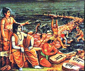
Rama with his allies building the bridge (canvas painting) |

Rama and Hanuman embracing each other after their successes
(Painting) |

Ram Sethu from Air (a close-up view) |
On 16th December 2006, India inaugurated dredging work connected to
the Sethusamudram project in the Rama Sethu (Adam's Bridge) area, near
the International Maritime Boundary Line off the Rameswaram coast. Ever
since then, the Rs. 60,000 million project has been mired in high
controversy.
The decision has made many of the Hindus, who comprise 82 percent of
the population of India very angry. They believed the project would
eventually destroy the Rama Sethu, the ancient bridge between India and
Sri Lanka.
What is this Rama Sethu (or Adam's Bridge)? In reality, it is a chain
of limestone shoals, between the islands of Mannar, near northwestern
Sri Lanka, and Rameswaram, off the southeastern coast of India. The
"bridge" is 48 km long and separates the Gulf of Mannar from the Palk
Strait. Some of the sandbanks are dry and the sea in the area is very
shallow, being only 1 m to 10 m deep in places.
The name, Rama's Bridge or Rama Setu (Sanskrit/Tamil; setu: bridge)
derives from the Sanskrit epic Ramayana, in which a bridge from
Rameswaram was built by allies of Rama that he used to reach Lanka, and
rescue his abducted wife Sitha from King Ravana. The sea separating
India and Sri Lanka is called Sethusamudram, based on the same episode.
The sage Valmiki says in the Ramayana, "that immense causeway
constructed by Nala in the bosom of the sea was built by the arms of
those monkeys of formidable exploits and it extended over a hundred
leagues.
Some brought trunks of trees and others set them up; it was by
hundreds and thousands that those monkeys, like unto giants, made use of
reeds, logs and blossoming trees to construct that bridge, rushing
hither and thither with blocks of stone resembling mountains or the
peaks of crags, which, flung into the sea, fell with a resounding crash.
The first day those monkeys resembling elephants, or immense energy,
full of high spirits and exceedingly merry, erected fourteen leagues of
masonry.
The second day, those highly active monkeys of formidable stature set
up twenty leagues. Bestirring themselves, those giants threw twenty-one
leagues of structure over the ocean on the third day and on the fourth,
working feverishly, they built up twenty-two leagues in extent.
The fifth day, those monkeys, industrious workers, reached to
twenty-three leagues distance from the further shore".
Man-made or Not
According to many renowned scientists, the bridge's unique curvature
and composition by age reveals that it is man-made. The legends as well
as archaeological studies reveal that the first signs of human
inhabitants in Sri Lanka date back to the a primitive age, about
1,750,000 years ago and the bridge's age is also said to be almost
equivalent.
This information is a crucial aspect for an insight into the legend
"Ramayana", which was supposed to have taken place in Tredha Yuga (more
than 1,700,000 years ago).
The ancient scriptures in Hinduism discuss about events in terms of
Yugas numerically four namely Sathya (1,728,000 years), Tredha
(1,296,000 years), Dwapara (8,64,000 years) and Kali (4,32,000 years).
The current phase according to the calendar is Kali, out of which
5000 years are supposed to have passed by. This means that Ramayana, to
have relevance with the bridge, should have taken place between 869,000
to 2,165,000 years back (between the time period 0.869 - 2.165 million
years).
Hindustan Times, too, recently claimed that NASA images serve as
evidence that events narrated in the Ramayana epic actually took place.
However, NASA has distanced itself from the claims related to the epic
Ramayana. It said, "The images may be ours, but their interpretation is
certainly not ours.
Remote sensing images or photographs from orbit cannot provide direct
information about the origin or age of a chain of islands, and certainly
cannot determine whether humans were involved in producing any of the
patterns seen."
Age
Various estimates were made regarding the age of the bridge and the
method of formation by Hindu archeologists and geologists:
1. Rama's bridge could only be 3,500 years old according to the
Centre for Remote Sensing of Bharathidasan University in Tiruchi.
2. Dr. C. Badrinarayanan, former director of Geological Survey of
India and a member of the National Institute of Ocean Technology (NIOT)
say it was not a natural formation. "Such a natural formation is
impossible. Unless somebody has transported them and dumped them there,
those reefs could not have come there. Some boulders were so light that
they could float on water."
He adds, "It is not a natural formation; the top portion of it
appears to be a man-made structure. To understand what I am saying from
the geological point of view, you have to get to know several things.
What is known as Adam's Bridge is originally a natural grade divide
separating the Bay of Bengal and the Indian Ocean to the south. So, the
geological aspects are different on either.
About 18,000 years ago, we had an Ice Age when the sea level was
lower by 130 metres than what it is now. Due to de-glaciation, the sea
level rose. Coral reefs are formed only on hard surfaces.
But during (our) study we found that the formation at the Bridge is
nothing but boulders of coral reefs. When we drilled for investigation,
we found that there was loose sand two to three meters below the reefs.
Hard rocks were found several meters below the sand."
3. However, The Geological Survey of India conducted a detailed
survey of the area and concluded that the structure was a natural one. A
premier institute had made 91 boreholes in and around the site to
ascertain the truth and the soil samples kept at the Sethu Project
Office could be verified.
Mystery
The origin of the bridge is yet a mystery. The Archaeology Department
of Sri Lanka also confirms the possible duration of the bridge's
existence to be around one to two million years. However the natural or
man-made status of the bridge is unknown.
Dr. S.U. Deraniyagala says that "the Himalayan foothills of the
Indian sub-continent have yielded evidence for humans having lived there
around two million years ago.
Although the earliest known dates for hominids in peninsular India
are ca. 600,000 years before the present, it is very likely that future
research will indicate an age comparable to that of the Himalayan
foothills, since there do not appear to have been any physical barriers
to prevent humans from being present in southern India contemporaneously
with their occurrence in the northern part of the sub-continent".
"Meanwhile, it is apparent that Sri Lanka was, more often than not,
linked to southern India by a land bridge during this period. It is
estimated that the sea level would have dropped sufficiently for
creating such a connection on at least 17 occasions within the last
700,000 years.
This phenomenon would have been caused by the rise and fall of the
sea level due to cold/warm fluctuations in the global climate. It is
therefore possible that humans were present in Sri Lanka from at least
as early as one million years ago. "
The bridge is as holy to Hindus as the Wailing Wall is to the Jews,
the Vatican to Catholics, Bodh Gaya to Buddhists and Mecca to Muslims.
In Europe, epics of Homer and the Bible are not considered to be myths,
but informal history.
The ruin of Troy, described by Homer, is already excavated. The
Israeli Government made serious efforts to excavate every place
mentioned in the Bible to find out its ancient past. In India, the
Archaeological Survey of India has discovered the ruins of Dwarka
submerged in water off the coast of Gujarat.
A Japanese ground Radar Company has found out ruins of huge places 30
meter under the ground of Ayhudhya. Thus, it is neither rational nor
scientific to rule out Ramayana and Mahabharata as just myths, but not
informal history of the ancient India. |


