The Ritigaha Oya Valley
W. J. Samuel
HIDDEN BEAUTIES: Nestling in the misty, forested, foot hills of the Dolosbage mountain massif, is the sleepy
|
Ritigaha-Waharaka cascades
|
little town of Bulathkohupitiya,
about 50 miles from Colombo via Avissawella and Karawanella.
It is a mere 100 ft above sea level but within seven miles on a
tortuous, narrow road you reach Dedugala where the elevation rises
dramatically to nearly 3000 ft above sea level.
Here, nature lovers could escape from the hustle and bustle of our
cities and savour a little bit of the up country air and you will be
able to return to Colombo in time for dinner.
There is a bus service on this route. From Dedugala, a new road has
been constructed to link with the Aranayake-Dolosbage/Nawalapitiya Road.
The present condition of this roadway has to be ascertained. The police
at the two ends - Bulathkohupitiya and Dolosbage - should be able to
advise motorists.
The Ritigala Oya flows serenely, meandering downstream to join the
Gurugoda Oya near Anguruwatta and unite with the Kelani Ganga near
Ruwanwella. Before this convergence takes place, it reveals some
sparkling roadside beauties - waterfalls.
|

Rukmal Falls
|
This Oya rises in a forested area west of an abandoned estate called
PEN-Y-LAN about 1 1/2 miles as the crow flies North West of Dolosbage.
This stream trickles down from a 3500 ft ridge between two estates -
Kellie Group in the North and Windsor Forest in the South. On the
eastern slopes of the watershed line the waters flow into the Maha Oya.
What is a watershed? It is a line of high land where streams on one
side flow into one river and streams on the other side flow into
another. It could also mean a turning point in the course of events.
Let us begin our beauty parade upstream with the Rukmal Fall about 13
Kms, east of Bulathkohupitiya. This is a 20m beauty with a lovely spray.
Rukmal refers to a plant producing fragrant flowers.
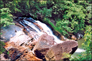
Our next fall is actually a series of cascades called
Ritigaha/Waharaka Fall about 9 km east of Bulathkohupitiya.
|

A view of Dulgale (3000 ft)
from the Bulathkohupitiya-Dedugale Road.
|
Here a ledge
of rocks narrows the river. The feeding brooks use from the Western
spurs of the 3500 ft. mountain Dotal Oya.
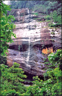
The next enchantress is Rikille Fall (30m) about 5 km east of
Bulathkohupitiya. A stream feeds the fall from Hunasaldeniya Mountain.
Kalupahana Fall is an unimportant water thread rising from forests
near Kalupahana a settlement about 2 km from Glenella from where it is
visible.
Dummale Fall (5m) next is not quite a road side beauty in the sense
it is off the main Bulathkohupitiya-Dedugala road. To view it one has to
take a road branching off to the forested Dulgala-Narangala mountain
area about 3 km from the turn off.
This fall is steeped in history as I discovered from Dharman
Wickremaratne’s wonderful Sinhala book titled ‘Sri Lankan Waterfalls’ in
which the author lists nearly 400 waterfalls. This book is a must for
nature lovers.
The author states in page 294. that this area was earlier called
Katuhena and that the farmer name of the
|
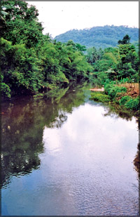
The Ritigaha Oya
between
Bulathkohupitiya-Dedugale
|
|

The swing bridge spanning Edanapalla-Yakalla on the
Ritigaha Oya.
|
stream was Thattibathgoda Ela.
King Walagamba is stated to have sought refuge in the nearby forests
after being defeated in a battle.
The king is said to have washed his eating vessel (Thatti) in this
stream. I rather guess that the good king smarting and sulking in the
forest after his defeat must have given vent to his frustration by
polishing off large helpings of country rice!
On Poya days an apparition of the golden Thatti is said to be seen
floating on this stream. This water course joins the Ritigaha Oya near
Bulathkohupitiya.
Our last waterfall is the 15m Punahela Fall above the village of
Punahela. This fall brings back nostalgic memories because I was born
nearby on Ederapolle Group, Bulathkohupitiya.
My father was a dispenser on this estate for 45 years and my sister
married the Superintendent. I have vivid memories of going hunting with
them as a lad in the paddy fields below this waterfall. My father, a
crack shot with his 16 bore shotgun, used to bag rather plump green
pigeons (Bata goya) which my mother used to
|
Rikille Falls
|
convert into delicious meat balls in her kitchen.
So why not our nature lovers, jaded businessmen, students and
teachers go up the Ritigala Oya Valley, well off the beaten track? A
word of advice here. Don’t expect star class hotels on this route. You
will be well advised to pack your own food and drink in your vehicle.
I paid a visit to this area last year and found that Bulathkohupitiya
has not developed at all. The only difference was that there were a
large number of three wheelers. I engaged one three wheeler whose driver
was very helpful in locating the various waterfalls on the road to Dedugala. At present this area will be affected by the southwest
monsoon, so you could plan your trip for early August.
Pictures by Nuwan GALPAYA
|


