|
 |
| Thursday, 27 January 2005 |
 |
|
| Features |
| News Business Features Editorial Security Politics World Letters Sports Obituaries
|
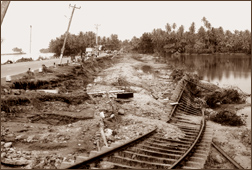
Living with tsunami: Future directions for coastal land use by Dr. Janaka Wijetunge The Coast Conservation Department (CCD) is the lead agency entrusted with the task of managing the coastal zone of Sri Lanka. The CCD has been implementing a full-scale Intergrated Coastal Zone Management (ICZM) Programme since 1990.
ICZM is the strategy that has been used in recent times to deal with the many disciplines involved with the coast (physical, environmental and biological) as well as various regulations governing the same, in a well-coordinated manner. The ICZM plan has identified four priority areas from among the many issues of the coastal zone during the time leading up to its preparation in the eighties. These priority areas are: coastal erosion management and land use; cessation of coral mining and control of sand mining; prevention of loss and degradation of coastal natural habitats; and protection of scenic areas as well as cultural, religious and historical sites. More recently, pollution of coastal waters has also been recognized as a major issue affecting the coastal zone. One primary regulatory measure adopted in the ICZM plan is that, any person wishing to engage in a development activity within the coastal zone, which includes the 300 metre wide strip of land mentioned earlier, is required to obtain a permit from the CCD. However, as would be expected, there are certain activities that may be engaged in without a permit, and these include, fishing, cultivation of crops, planting of trees and other vegetation. Also, nested within the coastal zone is a high-hazard exclusion zone, known as a 'setback' of width 60 metres from the mean waterline, where no construction is allowed. However, setbacks for certain water-dependent activities such as hatcheries for aquaculture and boatyards are determined on a case-by-case basis. The objectives of such setback zones generally include avoidance of damage from flooding and erosion, conservation of coastal ecology, and protection of natural view and of public access to the beach. Protection against hazards The Coast Conservation Act requires a review of the ICZM plan every four years to evaluate the success or failure of the existing management methods and accommodate new issues that may emerge in the future. Clearly, protection against coastal natural hazards was not considered as a major issue two decades back, and therefore, has not been fully addressed in the ICZM programme launched in 1990. However, now that the vulnerability of our low lying coastal lands to what goes on in the vast expanse of the Indian Ocean around us is abundantly clear, we must update the present ICZM plan to encompass protection against coastal natural hazards as a priority area of management. Sri Lanka's coastline faces the threat of flooding due to two sources: tsunami as well as storm surges. The furious journey of tsunami waves from deep oceans to beach and further inland needs no elaboration now, A storm surge, on the other hand, is a rise of sea level caused by water piling up against coast under the force of strong onshore winds such as those accompanying cyclone or other intense storm. Storm winds also build waves on top of the storm surge, which can raise the flood levels even more. Hazard zones Any review of the landward extent of the coastal zone within which restrictions should be imposed, whether it is 100 m, 300 m or 1 km, must necessarily be preceded by a detailed assessment of the inland distance within which significant damage had been caused by the recent tsunami. These field data should be supplemented with further inundation data from mathematical simulation of other possible scenarios. In other words, we ought to prepare inundation maps, indicating the extent of the coastal trip that would be affected by tsunami run-up, preferably for different recurrence intervals. This is because, surge of water running inland will travel a greater horizontal distance on a milder slope than on a steeper one. Therefore, one may argue that, instead of a horizontal distance, we should specify a certain vertical height, for example 5 metre topographic contour line, below which land use restrictions should be applied. It must also be added that, at certain places of the coast, the topography may be such that it could induce the build up of particularly high waves, and consequently, larger run-up height. These localities should be identified and special consideration be given. However, if it is too complicated to identify the costal zone, or the exclusion zone within it, based on a vertical elevation, then different horizontal distances must be specified according to the slope of the onshore land. For example, the width of this zone must be greater for the east coast with flat coastal lands than for the west coast. Coastal land use First of all, we must realise that it is neither economically feasible to neutralize the potential damage due to tsunami totally through engineering interventions such as building of giant seawalls, nor is it socially acceptable to exclude people and buildings entirely from the damage prone areas. Therefore, a key attribute of any action plan should obviously be a balanced management approach that can achieve a compromise between the above two competing factors after giving due consideration to hazard risks and likely damages, as well as the severity and the likely frequency of recurrence of such events. In this context, the ICZM programme with necessary revisions is a good tool because it can control development patterns, and combine coastal natural hazards mitigation with natural resource conservation. Clearly, the risk of tsunami or storm surges can be mitigated most effectively by avoiding or minimizing the exposure of people and property through good land use planning. Development should be prevented in high- hazard areas wherever possible; where development cannot be prevented, land use intensity, building value, and occupancy level should be kept to a minimum. Alternatively, new developments can be clustered on site areas where risks are the lowest. We also need to review what activities or infrastructure should be there on the coastal belt as well as what need not necessarily be there, in other words, the conforming and non-conforming uses of the coast. Do transportation corridors, for instance, Colombo-Matara highway and the railway, need to run so close to the sea? Obviously not, and therefore, with the exception of local access, highways and railways are a non-conforming use of the coastal zone. On the other hand, critical infrastructure such as hospitals. sewage treatment facilities, fire station and power substations should not be located in inundation zone. Relocation of these types of facilities out of inundation areas should be an integral part of any tsunami mitigation plan. Moreover, the recent disaster should be taken as an opportunity to eliminate such nonconforming uses, and to reshape the existing patterns of coastal development to minimize future losses. On the other hand, the sheer magnitude of the disaster in terms of the number of people affected also creates enormous pressure to rebuild each community quickly and exactly as it was before the disaster. The structures that must be sited in damage prone areas should be designed to be able to withstand the surge forces due to tsunami run-up, and with provision for emergency evacuation; structures that are already sited in high risk areas must be modified and strengthened adequately. In Hawaii islands, for example, lower levels of hotels have been designed to allow waves to pass through the ground floor parking and service spaces, leaving upper level rooms undamaged. Planting of groves of trees and preservation of coastal habitat that provide natural protection to wave attack, flooding and erosion, such as mangroves, are vital too. An added benefit of such conservation may stem from the fact that many tourists are becoming more interested in nature and physical activities such as hiking, biking birding, boating and fishing rather than just sunbathing on the beach. The coastal environment preferred by these tourists is much more natural (sand dunes, wetlands, abundance of plants and animals) than the traditional tourist environment of airports, highways, hotels, fast food outlets, all close to the water's edge. Clearly, we should not ban or discourage the use of the coastal zone for recreation activities, etc., and in fact, by all means, people should be allowed to enjoy the beach in a much more planned and organized manner. However, together with a reliable early warning system, we ought to have well laid out plans for both horizontal and vertical evacuation of people to safer places, for example, to nearby higher ground or to an upper floor of a tall building in an orderly manner, in case of an emergency. Furthermore, for efficient management of all of this, a National Tsunami Warning Centre functioning under a Disaster Preparedness and Management Authority that oversees all potential natural disasters must be set up. There has always been a major conflict between the exclusive use of beach sections by individuals and the common enjoyment of the shore by all. In my view, this narrow strip of land by the sea belongs to all citizens of the country as well as to flora and fauna that have their habitat there, so private property ownership along the beach should be discouraged. Disaster preparedness The long held belief that Sri Lanka is immune from the destructive forces of nature is a myth now. So, we need to instil disaster preparedness and safety consciousness into our culture. Schools should be the starting point for this; preparedness or the need to have plans for what to do, not only for tsunamis, but starting from a minor fire at home, should be taught at school level. Given the recent experience of a spate of natural disasters, tsunami as well as floods and landslides, we must emphasize the need to be vigilant and the need to take precautionary measures whilst going about with daily business as usual, like in the way many other developed countries around the world do. Meanwhile, it is the primary duty of the scientists and others concerned to watch for any signs of impending disaster all the time, and alert the nation suitably in a pre-determined manner. |
|
News | Business | Features
| Editorial | Security
Produced by Lake House |