|
 |
 |
| Thursday, 18 November 2004 |
 |
|
| Features |
| News Business Features Editorial Security Politics World Letters Sports Obituaries
|
Mini dams as an answer to the drought dread by P. M. A. Jayaweera, Chartered Civil Engineer
Recent studies have revealed that the amount of water added annually to the sea from 103 main river basins in Sri Lanka exceeds 56,000 Mcm (million cubic meters). On the other hand, we face the challenge to meet the demand for more water for drinking, domestic use, industries and irrigated agriculture, proportional to the increasing population. Environmentalists warn about a severe drought in near future. "25 percent of world's population or 33 percent of the population in developing countries live in regions that will experience severe water scarcity. In the next 25 years some one billion people living in arid and semi-arid regions will face absolute water scarcity - Water for Food, Water for Nature, Water for Life - IWMI 1998."
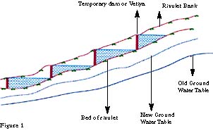
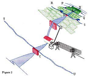
Yet we have much experiences of the droughts which prevailed in the recent past. Some of us have scarce memories and bitter experiences about a severe drought which prevailed for 20 months continuously just before floods in 1957. These facts are quite sufficient to think about a method of how to face such droughts to come, boldly with confidence. Many thousand years ago our ancestors also would have faced similar, even worse droughts than recorded. The basic theory behind is the soil and water conservation methods adopted in those good old days. Cascade tanks in arid regions are a good example. Even today we can see the ruins of a number of small tanks (called Olagam Wewas or Kuluwewa) above village tanks in dry zone areas. The main function of these small tanks is to store water to recharge the water table and to conserve soil. The main components of the tank are the strong earthen bunds across a small stream both ends or one end being bent downstream to facilitate the safe discharge of excess water at reduced velocity over soil in abundance. In addition to the above factors the area is rich in natural growth. As a result soil gets saturated and water infiltrates the ground. Consequently ground water level is maintained at a higher elevation for few months. Those days farmers utilised this saturated soil for highland crops for which the water requirement is less. They used tank water with strict management for cultivating paddy, the staple food. The method suggested in this paper is to construct very small temporary dams or Vetiyas at very close intervals. Materials may be chosen like straw, timber logs and earth or sand filled polysack bags. Using timber supports or rubble in two rows, a Vetiya or a small temporary dam is erected and puddle clay compacted in between. Labour also can be organised in the local vicinity at village level. For example, let us consider a Vetiya constructed 2 to 3m in length and 1.5m in height and the length of water spread up stream about 100m, (we can approximate this to a triangle). If we consider 100 nos., such water pockets per sq. km, we can estimate roughly, the quantity of water thus retained is each water shed and it can be proved easily these will not affect the existing storage schemes, despite the amount responsible for ground water recharge. Purpose of such a Vetiya is not only to store water. Important function is to divert water from two edges, allowing the soil to saturate in either bank. A large number of such mini dams or Vetiyas can be constructed in cascade pattern as if in a ladder. In this way one can imagine the vast number of Vetiyas that can be constructed in upper reaches, preferably in all watersheds. This concept is based on constructing a large number of small bunds or Vetiyas in upper reaches of tributaries and rivulets in a cascade pattern. Although the quantity of water retained by each mini dam is very small, each will divert considerable amount of water for ground water recharge, through the soil on either side of bunds if lateral ditches are available. Even after rain ceases because of the minute water heads in force all around the water shed, the ground water table will maintain at a higher level and the community will find easy access to drinking water at shallow dug wells. Somebody can argue when such a vast number of tiny water pockets are constructed in the upper reach, the downstream reservoirs will run short of water. Answer is no. Always it can be proved that this tiny water pocket will capture only a part of the excess water that simply falls into the sea annually, without being used for any benefit. Implementing strategy Stage (1) Construction of Vetiyas or small bunds at farmost and uppermost places of the watershed or more or less at the beginning of river tributaries and minor streams. This is a temporary work planned only for about 2 years. Planning and construction will be done by the local community with the guidance of relevant government agencies and authorised NGOO. Active participation of Samurdhi societies, farmer organisations, rural development societies and any other village level welfare societies will be the key bodies in implementing this programme. At the beginning relevant government agencies will have to play an important role in motivating and encouraging the rural community for the said work. Because usually our community always expects "instant benefits" for any work. The work can be organised at "shramadana" or voluntary basis and at the same time government can urge from NGOO, philanthropists and well wishers for any desired contributions. The materials for construction of the said Vetiya can be found locally and will not cost much. Jungle timber or rock boulders, polysacks or straw and puddle clay can be used for this temporary bunding. Soil or sand filled polysacks are packed in two rows to the required height with the help of timber or boulders and puddle clay packed in between. Constructing a Vetiya has nothing technical but common sense to the normal Sri Lankan villager. It is an inherited skill that has been transformed from generation to generation. land acquisition is not required, because initially it will be planned for storage only up to bank level. Flank bunds can be provided to reduce the spread area, wherever necessary. Special feature in this concept is to construct Vetiyas in cascade pattern, almost like a ladder. Upper surface end of each water pocket will touch the foot of upper Vetiya. Stage II Once the Vetiyas are constructed in large numbers, next step is to construct contour ditches (or diversion canals, as the case may be) in transverse direction on either side of banks to the farmost places possible. Although the contour levelling is not required, eye estimation is quite sufficient in executing this. There again the inherited knowledge in cutting contour canals and ditches can be adopted in this task. At this stage sometimes land problems may arise. Some extremists, due to may be ignorance, will not allow to cut any canal or ditch on their lands. In such instances, the relevant agencies should intervene to solve the problem in an amicable manner also attempting to convince them about the improvement of fertility of soil when water enters land. At this stage, the land owners on either banks can be encouraged to cut contour ditches on their respective lands. Once stage II is completed, the function of the system can be explained in this manner. For example, let us assume A,B,C are such temporary dams constructed in cascade, water spread area is very small. Storage capacity of each tank is also very small. Suppose AP, AQ, BR, BS, CT and CU are contour ditches constructed at locations A,B,C respectively. Before the construction of this system all rain water flows along the natural stream (C.X). Now part of the rain water flows through the ditches also and makes the soil saturate and further, part of run off will infiltrate soil and recharge the ground water. Now suppose a similar mechanism is adopted in the adjoining minor stream also. Ground water will be recharged in the area concerned too, like that if we adopt a multiple water conservation system the ground water level will be maintained at a higher level even after rain is ceased, for a considerable period. Stage II is also involved to identify the geological lineaments in terms of practical significance. At the places where fissures, dykes are found, the storage and diversion could be avoided. At the places where the system functions well, the permanent structures could be planned and constructed, depending on the resources. (Money, labour, materials etc.) Stage III With the help of community level organisations more conversant planning could be done using expert knowledge. At this stage community representatives are fully aware of any multi-purpose system and they would give any material support in the planning process. For example, mini hydropower projects and augmentation projects can be planned wherever possible. Government and non-governmental organisations can contribute to these projects by expert knowledge, financial aid, authority etc. Anyhow these systems should also be planned only up to the local implementing capacity. Because the moment it exceeds the local limits, we have to wait till foreigners help us, or in other words till foreigners give loans, aid in bulk. The main disadvantage of waiting for loans is that a major portion of such loans will be taken back then and there to the donor agency in terms of consultancy, machinery and materials. Another considerable portion will be sieved off by the contractors. The worst side of it is deforestation in the name of development, causing enormous damage to the environment. For examples, Chain felling in the Gal Oya project and severe jungle clearing in Mahaweli reservoir projects, can be considered. An alternative method of harvesting water is to construct farm ponds in plain valleys of low slopes having clayey soils. Although the dimensions of such a pond can be fixed according to the site and soil conditions, some dimensions are shown below, which may be deemed suitable. The entire water shed should be managed by a body (Catchment Management Agency-CMA) consisting of representatives, for each main tributary, sub tributary and minor tributary. Representatives for each tributary level may be elected from local folk or water users. Anyhow key persons of C.M.A. should be appointed by the relevant Minister, because they are responsible for taking decisions and for considerable authority needed in decision making and the implementing process. |
|
News | Business | Features
| Editorial | Security
Produced by Lake House |