|
 |
| Wednesday, 11 February 2004 |
 |
|
| Features |
| News Business Features Editorial Security Politics World Letters Sports Obituaries
|
Eco-sensitive housing Archwatch Forum at its bi-weekly meeting last week decided to respond to requests made by eco-friendly people through this page and to emphasise the need for 'eco-sensitive housing'. Hence this article on the subject by Architect Jayantha Domingo carried in the SLIA Publication Architect Vol. 101 No. 15. Forums co-chairman Chartered Architect Veranjan Kurukulasuriya, who is also the Deputy Director Architecture Department of Town & Country Planning chaired last week's Forum meeting. by Jayantha Domingo
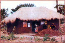
This simplicity essentially has advocated limitations on the use of material resources in the day-to-day activities of the people. This in turn influenced the folk building tradition which is essentially the home building process of the people. Since the settlements of the people in the past were basically in the dry zone they had to be located in close proximity to a source of water for the purpose of direct human consumption, the cultivation and the raising of animals. The source of water in this case was the rain fed tank (Wewa). Wewa itself was a source of food in addition to bring a source of water for irrigation. The houses were located in a cluster form which gave them social cohesiveness and sense of security and protection from the wild animals in the surrounding jungle. Thus a minimum are a of forest cover was cleared to allow for the human settlement and the production of food. Disturbance to the ecology was bare minimum. The people were very conscious about the importance of the continuous existence of the flora and fauna in the jungle and the water sources, on which they were depending partly for the supply of food and also for building materials for the erection of their houses. The ownership of land was transformed from parents to children and sub division forming strict legal and physical demarcations were not carried out. Hence in the traditional villages the land fragmentation did not take place. Thus group ownership of land prevailed in contrast to the individual ownership in the west. With the colonisation by West the crop pattern in the country also changed into a commercially oriented one based on wet zones. With the introduction of coffee, tea and rubber in large scale and the development of infrastructure facilities to reach these cultivations, the settlements started to get established in the wet zone.
The Sri Lankans who were quite at home in establishing their settlements in the dry zones were completely ill-equipped to face the new conditions prevailed in the wet zone. Hence they had to merely follow the British settlement strategies and land sub-division systems.
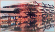
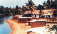
Although there may be other causes, this was the main factor which encouraged the strict land sub-divisions with no proper concern or understanding of the particular topographical or climatic conditions. With the increase in population and the reaching of new infrastructure and basic services facilities to certain selected areas of the country, uncontrolled land sub-divisions started to take place in all the sub-urban areas initially and started spreading into rural areas subsequently. With this background, if we look into the major events related to housing development which took place during the last decade or so, we can briefly discuss the major positive and negative impacts on the eco-systems which were results of same. State sponsored housing development activities The major housing programmes which were initiated and implemented by the state basically fall under three categories. i. Programmes with direct intervention by state in planning and construction. ii. Programmes implemented by the state with user participation. iii. Housing loan programmes with minimum intervention in planning and construction by state. Under the first two categories the government had the opportunity to do the overall planning both at the programme level and the project level and hence there was a good scope for the state to look seriously into the aspect of eco-sensitive housing development. This was possible right from the selection of sites, formulation of development strategies to the layout, planning, design of housing units and selection of materials and technology. Most of the large housing projects which came under the first category are located either within the Colombo Municipal Limits or suburban areas within Colombo, Gampaha and Kandy districts. If we look into the aspect of site selection for the projects within the Colombo city limits and other urban areas they were low lying or unfertile lands. Hence the adverse effects to the vegetation which prevailed prior to development is not very obvious and immediate. Since all of them depended on the pipe-borne water and pipe-borne sewer and waste water disposal systems, the pollution of the ground water in the localities did not take place. One of the adverse effects which may have resulted is the blocking of the storm water drainage pattern in the area thus aggravating the situation of flooding during rainy season. The other projects which were outside the urban areas were located in coconut or rubber lands with the complete removal of the existing vegetation, thus damaging the prevailing eco-system. Furthermore these projects had to depend on the disposal of sewerage and waste water within the project site. In general since these lands were of undulating nature topographically, they were cut and filled to suit the type houses which were to be constructed thereon. Due to the extensive cutting and filling of land and macadamising of internal roads, the drainage patterns within the site and the surroundings has been disturbed. In some of these schemes the overflowing of effluent from sewer disposal systems have polluted the streams and the water wells in the vicinity and also killed the vegetation in the surrounding lands. Further to this the large housing projects which were constructed within the Kandy and Nuwara Eliya districts may pose a threat to the eco-system in the form of possible land slides due to erosion and disturbances to the endemic species of flora and fauna. Hence selection of land for major housing development projects is a very sensitive issue which should not be done in isolation by the developer. The National Planning authorities should prepare land use policies and detailed land use maps where not only the basic division of land uses are indicated but also appropriate gradings of density to the identified residential zones are given considering the topographies, climatic conditions, desired densities and other special inherent features. Land sub-division under housing loan programme The housing loan programmes of the state basically, came under two categories namely urban and rural. In the rural areas the housing loans were given mainly to the people who owned lands to build their houses. Hence strict sub-divisions were not forced upon the people by the state. Since the lands are not very scarce in the rural areas and the densities are low the pollution of ground water and erosion due to extensive cutting of earth did not take place in large-scale. But the situation with regard to land in the urban areas where housing loans were to be disbursed was of entirely different nature. There were basically two strategies adopted depending on the land ownership pattern. One of the strategies adopted was the upgrading of the existing sub-standard settlements (slums). The upgrading took place mainly in the areas of infrastructure and services and up to a certain extent in the raising of the standard of construction of the housing units. Although this could be argued as a legalising of the existing slums, this has a positive impact on the eco-system at least for the time being in terms of improvement to the drainage system. Moreover the soft nature of interference do not bar the possibility of more organised developments in future. The other strategy used in the urban housing loan programme was to provide buildable land lots having the minimum possible extent which paid no heed to the existing land sub-division regulations in the urban areas. The lands were sub-divided into lots having extents of 1 1/2 to 3p (40 sq. mtrs. - 80 sq. mts). This has created a complete chaos in terms of land fragmentation, insanitary light and ventilation conditions, violation of land use policies, storm water drainage problems and over-burdening of the existing services networks. Since the shanty settlements were essentially in the low-lying lands owned by the state or on the canal banks, the damage done to the eco-system by legalising same would be enormous and diversified. The canal bank settlements were originally located with the rear of the houses facing the canal treating it as a place to dispose all the solid and liquid wastes. The upgrading of these settlements created a pathway between the canal and the houses and promoted the facing of the front of the houses to the canal. This strategy and the provision of pipe-borne water and sewer facilities have minimised the damage caused to the eco-system previously. Hence this could be considered as a programme which is completely detrimental to the eco-system. In the case of low-lying areas the unplanned filling which even encroached the flood areas has caused irreparable damage to the eco-system. Sub-division of land by land sales companies The demand for land lots for housing in the sub-urban and the other areas where the national road and the electricity networks have reached has been on the increase during the last two decades and it has reached alarming scales in the last 10 years or so. In the absence of a national land-use policy, there is no controlling mechanism over this, activity except for the local authority land sub-division regulations which will only look into the aspect of lot sizes, access road widths etc. The existing regulations on land sub-divisions also vary from one local authority to another and the officials who are dealing with this subject at local authorities do not possess a comprehensive knowledge as to the various issues connected including the specific lot size limitations. A canal bank settlement Hence, it has become a lucrative business for the land sale companies who are involved in this at large-scale. Hundreds of land sale companies have sprung up in the country even in small towns who started buying land from the land owners at very low prices and in the guise of selling serviced land lots they merely sub-divide the lands providing a network of internal gravel roads. The selling price of the so-called serviced plots is about 3 times the buying price. The lot sizes vary from about 15p to 6p and even in areas where there is no pipe-borne water supply or sewerage disposal facilities the lot sizes have gone down to even 6p. Since these projects have to depend on the well water supply, leaving adequate space between wells and septic tanks to avoid contamination and between the wells themselves to ensure a proper yield are vitally important. In addition to this the ground water is also getting polluted and dried up. These factors have been totally ignored by the land sales companies and the local authorities who allow such activities. Land sub-division under housing loan programme The housing loan programmes of the state basically, came under two categories namely urban and rural. In the rural areas the housing loans were given mainly to the people who owned lands to build their houses. Hence strict sub-divisions were not forced upon the people by the state. Since the lands are not very scarce in the rural areas and the densities are low the pollution of ground water and erosion due to extensive cutting of earth did not take place in large-scale. But the situation with regard to land in the urban areas where housing loans were to be disbursed was of entirely different nature. There were basically two strategies adopted depending on the land ownership pattern. One of the strategies adopted was the upgrading of the existing sub-standard settlements (slums). The upgrading took place mainly in the areas of infrastructure and services and up to a certain extent in the raising of the standard of construction of the housing units. Although this could be argued as a legalising of the existing slums, this has a positive impact on the eco-system at least for the time being in terms of improvement to the drainage system. Moreover the soft nature of interference do not bar the possibility of more organised developments in future. The other strategy used in the urban housing loan programme was to provide buildable land lots having the minimum possible extent which paid no heed to the existing land sub-division regulations in the urban areas. The lands were sub-divided into lots having extents of 1 1/2 to 3p (40 sq. mtrs. - 80 sq. mts). This has created a complete chaos in terms of land fragmentation, insanitary light and ventilation conditions, violation of land use policies, storm water drainage problems and over-burdening of the existing services networks. Since the shanty settlements were essentially in the low-lying lands owned by the state or on the canal banks, the damage done to the eco-system by legalising same would be enormous and diversified. The canal bank settlements were originally located with the rear of the houses facing the canal treating it as a place to dispose all the solid and liquid wastes. The upgrading of these settlements created a pathway between the canal and the houses and promoted the facing of the front of the houses to the canal. This strategy and the provision of pipe-borne water and sewer facilities have minimised the damage caused to the eco-system previously. Hence this could be considered as a programme which is completely detrimental to the eco-system. In the case of low-lying areas the unplanned filling which even encroached the flood areas has caused irreparable damage to the eco-system. Sub-division of land by land sales companies The demand for land lots for housing in the sub-urban and the other areas where the national road and the electricity networks have reached has been on the increase during the last two decades and it has reached alarming scales in the last 10 years or so. In the absence of a national land-use policy, there is no controlling mechanism over this, activity except for the local authority land sub-division regulations which will only look into the aspect of lot sizes, access road widths etc. The existing regulations on land sub-divisions also vary from one local authority to another and the officials who are dealing with this subject at local authorities do not possess a comprehensive knowledge as to the various issues connected including the specific lot size limitations. A canal bank settlement Hence, it has become a lucrative business for the land sale companies who are involved in this at large-scale. Hundreds of land sale companies have sprung up in the country even in small towns who started buying land from the land owners at very low prices and in the guise of selling serviced land lots they merely sub-divide the lands providing a network of internal gravel roads. The selling price of the so-called serviced plots is about 3 times the buying price. The lot sizes vary from about 15p to 6p and even in areas where there is no pipe-borne water supply or sewerage disposal facilities the lot sizes have gone down to even 6p. Since these projects have to depend on the well water supply, leaving adequate space between wells and septic tanks to avoid contamination and between the wells themselves to ensure a proper yield are vitally important. In addition to this the ground water is also getting polluted and dried up. These factors have been totally ignored by the land sales companies and the local authorities who allow such activities. ###################### The aesthetics of the top... Continued from 28/01/2004 by Archt. Shereen Amendra The vast platter of the landscape holds and binds to it whatever centrepiece of architecture it chooses to display. The relationship is hardly binding, but inextricably linked so that the impoverished human soul is led to the monumentality of the structure and taking in the meat of it transcends to the apex, the pinnacle and the vastness of the sky beyond. Such is the power of structures whether slender and tall, majestic or monolithic and monumental, with the vastness of the surrounding landscape enhancing and yet giving deference. The Kiri Vehera at Kataragama can be experienced as much as the structures of the Nile Valley, Agra, versailles and others around the globe. Wherever the landform allows, the vastness of flatlands gives way to structures stamping their importance by occupying a hilltop or otherwise lofty location. Here too, the most obvious and evident aspect of its architecture is its shaping and termination against its backdrop. Landform, avenue, perspective, focus, acknowledger, surprise - whatever means the shaper of the landscape employs for the pilgrimage of the eye and mind, the viewer's attention is drawn to the overall silhouette and apex of the structure by which means the viewer receives a response. Landmark - a mark of power In modern cities the ability to control or contrive a designated landscape to enhance or give deference to a particular building is limited. The city itself is the landscape. Most well-designed and planned cities are such that the central business district or similarly termed area where commercial activity is a peak can easily be recognised by its high-rise structures. However, this is not always the case and in an emerging city such as Colombo we see isolated high-risers. However, these structures, whether here in Sri Lanka or elsewhere make their mark on the urbanite and urban visitor alike. Their sheer height rising above the surrounding structures silently cries out, powerfully marking its presence in the urban scene. Wherever one may traverse in its region, the building will unmovingly guide and orient, while presenting a changing face with each visual encounter. However, it is not the particular face which impinges on the memory but the overall silhouette and indeed the termination. Truncated versions of the Empire State, the former Twin Towers or the Chrysler buildings all look much the same. But topped with their respective upper floors each has the power to transform into separate identities with the stately and elegant Chrysler stealing the show. Shaping and positive termination is even more evident among most of the modern architectural 'stars' the world over. The ability to recognise a structure from afar, increasing its potential as a reliable landmark. |
|
News | Business | Features
| Editorial | Security
Produced by Lake House |


 The main religious and cultural practices in Sri Lanka always promoted
the essence of simple ways of life. The simplicity and clarity prevailed
in the whole range of activities starting from food and clothing, habits,
religious and cultural practices and further to the planning and design of
built environment.
The main religious and cultural practices in Sri Lanka always promoted
the essence of simple ways of life. The simplicity and clarity prevailed
in the whole range of activities starting from food and clothing, habits,
religious and cultural practices and further to the planning and design of
built environment.