Hurricane Earl churns across Atlantic
The US East Coast was keeping a watchful eye on an intensified
Hurricane Earl on Tuesday, amid warnings it could cause catastrophic
damage from North Carolina to New York.
Packing fierce winds of up to 135 miles (215 kilometers) an hour,
Earl, now a Category Four storm, was churning across the Caribbean,
brushing past Puerto Rico as experts forecast it may reach North
Carolina by midweek and travel northward from there.
If the forecasts are accurate, Earl will likely wreck plans for
vacationers this Labor Day weekend, prompting them to desert area
beaches.
|
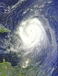
Hurricane Earl. AFP |
It came on the heels of Hurricane Danielle, blamed for rough surf and
riptides in New York and New Jersey last weekend.
On the five-point Saffir-Simpson scale used by the US National
Hurricane Center (NHC), a Category Four storm carries a warning that
“catastrophic damage will occur,” with a high risk of structural damage.
Earl was churning west-northwest at 14 miles (22 km) per hour,
dumping heavy rains and whipping up massive waves as it continued its
arc past the Lesser Antilles, with the eye of the storm centered some
110 miles (175 km) north of San Juan.
Even though it may strengthen in the next day or so, the storm was
not projected to make landfall immediately, and earlier hurricane
warnings for Puerto Rico and the US and British Virgin Islands were
downgraded.
The NHC said tropical conditions would affect portions of Puerto Rico
early Tuesday, with stronger winds likely in elevated terrain. The
weather pattern was expected to subside later in the day before
spreading to the Turks and Caicos islands.
One weather model has Hurricane Earl skimming the Outer Banks, in
North Carolina on Friday, and possibly reaching as far north as the
Canadian province of New Brunswick by Saturday.
Midway through the annual Atlantic hurricane season, the eye of the
storm passed over the French islands of Saint Martin and Saint
Barthelemy early Monday, bringing down trees, blocking roads and
snapping power lines. Thousands of people were left without power.
French Overseas Territories Minister Marie-Luce Penchard told AFP
late Monday that it appeared there had been no loss of life.
But “the wind is so strong that people still can’t go out,” she said.
She was planning to travel to the two islands on Tuesday to assess the
damage, but said a desalination plant had been hit and water supplies
had been disrupted.
The storm could dump up to 12 inches (30 centimeters) of rain,
especially in higher elevation, the US hurricane center said.
“These rains could cause life-threatening flash floods and
mudslides,” it warned.
Winds of up to 170 kilometers (105 miles) an hour were registered in
Saint Barthelemy, emergency officials in Guadeloupe said.
The northern half of Saint Martin is French territory, with the
remainder — known as Saint Maarten — belonging to the Netherlands. Saint
Barthelemy lies to the southeast.
French President Nicolas Sarkozy hailed “the discipline and courage”
of the islands’ residents, saying they were being sorely tested by the
hurricane.
Meanwhile, Tropical Storm Fiona was moving quickly westward near 23
miles (37 km) per hour, and centered some 670 miles (1,080 km) east of
the Leeward Islands. It was expected to skim the islands early Wednesday
and packed top winds of 40 miles (65 km) per hour.
AFP |


")


