Ownership of land made simple, clear and accurate
Ranil WIJEYAPALA
Inheriting a land with a clear deed is a foundation for life for any
citizen, as it adds more strength to him or her to reach prosperity in
life. But this has become one of the biggest challenges in their lives
due to shortcomings especially the complex nature of the land deed
registration system.
Not only has it created problems to the public, but it has also paved
the way for many racketeers to make easy money, in the means of the
complicated nature of deed registration system. The intricate nature of
the deed registration system has enabled any person to register a deed
by his or her name with the assistance of a notary public, and also to
sell a non-existing land to anybody on a forged deed.
People with little knowledge on land transactions easily fall prey to
this vicious system and the most unfortunate thing is that some of the
cases end up with suicide or other form of tragedy.
|
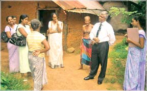
Land officers visiting houses of villagers. |
Sometimes, they have been dragged into land disputes continuing for
generations without reaching settlement. It not only wastes their hard
earned money but also leaves the disputed land unused.
The complex nature of the deed registration system, absence of a
simple system to check the authenticity of land ownership; its extent
and boundaries, and the lengthy legal statements inserted in the deeds,
which could be understood only by the people with a fair knowledge on
legal jargon have distanced this deed registration system from the
common masses.
The situation with regard to the privately owned land is worse as
majority of the private land owners are without ownership. This
situation has left majority of land plots without proper deeds.
“It was due to this complex and aggravating situation we had to think
of a novel and simple system to replace the current complex system of
deed registration”, Land and Land Development Ministry Additional
Secretary W.M. Jayathilake said.
The Registration of Title Act no.21 of 1998 came in to effect to
settle the land ownership.
“Through this Act we are going to replace the current deed
registration system with the Title Registration System”, Jaythilake
said.
According to him, the Land and Land Development Ministry has embarked
on this project under the ‘Bim Saviya’ program with the objective of
improved utilization of land as a development. resource
|
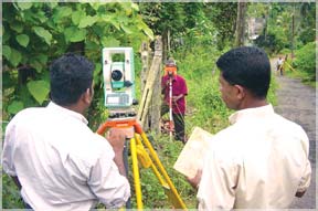
Surveying the lands |
“The program is initiated as a basic component of the Gama Neguma
activities introduced by Mahinda Chinthana program. It is expected to
provide a clear and Government guaranteed ownership to all legitimate
land owners by empowering them to develop their lands better and promote
personnel development by using the land to generate capital. At the same
time it provides a land information database which will be the base for
an efficient and scientific land management”, Jayathilake added.
But implementing this program is not an easy task due to the
complexity of the status of the lands, its ownership and the disputes
related to these lands.
The Bim Saviya program has been assigned to survey and prepare plans
for every land plot and register the land along with the ownership and
the right encumbrances and issue a title certificate.
The enormous task which has been undertaken by this program is
evident considering the number of land plots estimated nearly 11 million
due to fragmentation of lands for sale . Over 60 per cent of the lands
are without clear deeds.
The Land Ministry, Land Settlement Department, Survey Department and
the Registrar General Department will involve in this long and arduous
project. “We have to implement this program at village level as it is
the simplest administrative unit in the country”, Jayathilake added.
The Land Ministry with Divisional Secretaries’ assistance forms
Coordinating Committees chaired by the Divisional Secretary in charge of
the Division to activate the initial stages of the program.
The committee will also comprise the Assistant Survey Superintendent
from the Survey Department, Assistant Commissioner from the Land
Settlement Department, Assistant Registrar, Provincial Land
Commissioner, Representatives from respective local bodies, Grama
Sevaka, Land Officer and field officers.
Once the committee decides to implement this program at village level
the Grama Sevaka will be dully informed and the villagers will be
educated about this program after convening a meeting at village level.
Following this meeting, each villager will be informed of a date on
which a surveyor and inquiry officer visit their houses. On the
particular date the land owners should submit their deeds, and other
documents to prove their land ownership and the surveyor will make a
rough note about the boundaries of the respective land plot.
At this stage people have to sign a document agreeing to the
boundaries of the land. If there are any disagreement with regard to
boundaries they will be given two days to settle the disputes. If they
could not come to a settlement within the given two days the matter will
be forwarded to a reconciliation board set up at village level. If they
cannot reach a settlement even at this level the cases will be forwarded
to Courts for legal settlement.
“We are trying our best to settle these disputes at the conciliatory
board level”, Jayathilake added.
At this stage the Surveyors prepare a plan for each village and each
land parcel at zonal level and measure the extent of the land and
provide 12 digit number which include national grid reference number to
that land to easily identify the land parcel. The inquiry officers will
continue with their inquiries to clear the ownership of the land.
Once the master plan for the village and the boundaries of each land
parcel is prepared by surveyors with the assistance of the DS and Grama
Sevakas the Land Ministry will issue a gazette notification publishing
the rough map of the lands along with the list of owners prepared by the
inquiry officers or filed officers.
The advantage of the Bim Saviya program is that even those who do not
possess deeds or any other documents to prove their ownership, with the
help of the Grama Niladari and other filed officers, the Land Settlement
Commissioner can take a decision on the ownership enabling the people to
obtain a title certificate for their land.
Even those who are in the same land, without dividing the land, can
make use of the program to divide the land with the consent of all
parties.
“With regard to the state lands we have to deal with Land Development
Ordnance, Crown Land Ordnance, Land Grants Special Provisions Act, Land
Reforms Law, and with the relevant state agencies under which the
ownership of the land comes like the National Housing Development
Authority, Urban Development Authority, Archaeological Department,
Forest Department, Wildlife Department and Mahaweli Authrity “,
Jayathilake added.
To settle land disputes we forward some cases to Conciliatory Boards
with the nominations from the Divisional Secretary, leaders of the area
and Grama Sevaka. “Most cases regarding the boundaries of the land
parcels can be settled at the Conciliatory Board level and the cases
that cannot be settled at the conciliatory board level forwarded for
legal settlement”, he added.
Once the process of clearing the land ownership is completed to the
satisfaction of the Registrar General, the title certificate which
includes the plan of the land parcel, its 12 digit identification number
with national grid reference and its owner, will be registered at the
Registrar General Department which comes under the Public Administration
Ministry.
“After the completion of this process people can inherit a clear
title certificate which is legally accepted by any private or state
sector institution for any form of transaction”, Jayathilake added.
According to P.M.P. Udayakantha, Assistant Secretary to the Land
Ministry and the Head of the Bim Saviya program, the program has been
implemented in six Divisional Secretariat Divisions (Udapalatha, Doluwa,
Balangoda, Divulapitiya, Homagama and Tambuttegama and a procedure
adoptable to Sri Lanka has been identified and agreed on.
“A 15 year year program has been prepared to cover the whole country
by Bim Saviya Activity”, he added.
“Institutional, legal and procedural improvements are now being
carried out as a preparation for national level activity”, Udayakantha
said.
In addition several critical amendments to the Registration of Title
Act have been identified and the amendments are formulated by the legal
draftsman.” They are required to be passed by the Parliament soon”, he
added.
The Bim Saviya program has selected Divisional Secretariat Divisions,
Gampola, Doluwa, Udunuwara in the Kandy district, Divulapitiya and
Meerigama in the Gampaha district, Balangoda and Weligepola from the
Ratnapaura district,
“With the completion of this program all the lands in the country
will be registered under one data base at the Registrar General
Department along with the land owners. This is completely different from
the earlier system of deed registration as the land registration is not
mandatory under deed registration system”, he added.
As a result of the Bim Saviya program a digital Land Information
System will be established and made available for planners and decision
makers. It will be an asset for scientific land administration, he said. |


