How Ruhuna came to be a neglected land
Ruhuna, which at one stage of our history fed the entire nation,
provided safety to our kings when invaded by the hordes from South
India, came to be an impoverished land under the British occupation with
parts of it remaining so even today.
S.Pathiravitana
The land of a thousand lakes is how tradition
described the land below the Balangoda hills sweeping down to Hambantota.
Travellers in a position to draw comparisons, says R.L.Brohier in his
absorbingly interesting Ancient Irrigation Works in Ceylon, record that
there is " perhaps not a scene in the world which combines sublimity and
beauty in a more extraordinary degree". He was quoting Emerson Tennent,
a great admirer of the beauty and wonder of Lanka.
 Tennent
goes on describing the spread below Balangoda over which he says, " for
nearly sixty miles the prospect extends unbroken by a single eminence
till far in the distance the eye discerns a line of light, which marks
where the sunbeams are flashing on the waters of the Indian ocean." It
is on this stretch that the thousand lakes lie, but not visible,
possibly buried under the jungle that has overrun it. Tennent
goes on describing the spread below Balangoda over which he says, " for
nearly sixty miles the prospect extends unbroken by a single eminence
till far in the distance the eye discerns a line of light, which marks
where the sunbeams are flashing on the waters of the Indian ocean." It
is on this stretch that the thousand lakes lie, but not visible,
possibly buried under the jungle that has overrun it.
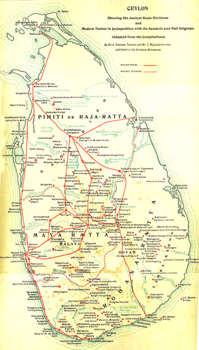
But the Thimbolketiya one inch map, which Brohier presents us with,
gives some idea of what the thousand-lake country (Wil-lassa, Wellassa
?), 440 of which he has counted, would have looked like. You soon begin
to catch some of the excitement that grips Brohier, for here he says is
still visible the model of the marvellous ancient irrigation system of
the country, not the country of the huge dams and immense waters of the
Raja Rata, but the land of the smaller tank which can only be rendered
as, small is beautiful.
You begin to wonder why no government in this country, beginning with
the British days, has revived this irrigation system which combines
beauty with economy, and has helped to make it once the granary of
Ruhuna, if not the whole of Lanka. Some efforts, though, seem to have
been made in the British days to relieve the suffering and poverty of
the people here, eking out a miserable living without water. But since
this catchment area spreads over three provinces, Uva, Sabaragamuwa and
the South the efforts of any single administrator would have come to
nothing had any one of them tried to move in the matter.
The exception perhaps was that of Government Agent Wace ( 1873-1906)
and that was because he confined himself only to Sabaragamuwa. He had a
dream that the waters in the Kolonne hills could be drawn to nourish the
soil around Embilipitiya which, however, took nearly half a century to
become a reality, and that too when he was no longer there.
Agriculture
How is it that the agriculture in the southern half of this island
suffered so much, considering that the foreign invader who came to the
north seldom came down south? Brohier points to the unsettled conditions
that prevailed during the Portuguese and British times as a contributory
cause.
Britain had also to contend with a rebellion that came in 1818, once
the people realised that the life and culture of the country was
drastically changed after it was handed over to the British. We have to
go to Paul E Pieris to find out what happened.
In his Sinhale and the Patriots 1815-1818 Pieris has this to say:
The explanation of the state of some at least of these tanks is
supplied by James Campbell, who after succeeding Macdonald as Commandant
at Galle, spent many years in Sat Korale as a military and judicial
officer.
He mentioned as "the greatest injuries done by our troops, the wanton
destruction of the coconut palms, and laying waste their rice grounds,
by breaking down their immense embankments constructed to retain the
water."
To restore them he pointed out, would involve years of labour. The
indictment against his people may well be founded on a substantial basis
of truth, for although no specific order to destroy irrigation works has
been traced, to do so would be the corollary to the policy of starving
the people into submission.
The policy of starving the people into submission was not the only
atrocity committed by the British, but this is not the place to talk
about it, perhaps when a commission is appointed some day to try
colonial atrocities, as a precedent has been set up for the Jews after
World War II. Brohier says the neglect of this region was such that a
topographical survey of the South was started only in 1902, about a 100
years after the British occupation of the country.
Still we hear talk about the neglect of Ruhuna. If we are
sufficiently interested and proud of our past, the thousand-lake country
could still be made a reality, and at a time when the world is talking
about sustainability and environmental pollution of every kind. The
irrigation system we had here thousands of years ago, was a remarkable
example of how a poor country could achieve big things by doing it in
the simplest and the most environmentally friendly way. It could remain
as a model to what is now called the Third World, another typical
Western distortion, when in fact it IS the first in origin.
The multi-purpose dinosauric irrigation systems we have been advised
to adopt do not seem to be achieving what they have promised. They have
of course helped the rich to get richer, but the poor as always remain
neglected. Samanalawewa and Lunugamvehara in the south are two good
examples of what we have in mind.
Parakrama
Besides the thousand wewas that adorned this part of our country
there was also constructed a single huge one known, curiously enough, as
Pandikulam. Though it is marked on the one inch map that Brohier
reproduces, the name of this tank does not seem to be in use today. When
a controversy arose at the end of the 19th century as to which expanse
of water the Mahawansa refers to as the 'Sea of Parakrama,'
Henry Parker, an engineer, and a great admirer of the technological
achievements of the Sinhalese, said that the ancient chronicler had the
Pandikulam in mind.
Parker may have come to this conclusion after surveying what remains
of the proud glory that was once Pandikulam.
There may have been a need for such a tank considering the amount of
water that gushes down from the Horton plains. So vast is the quantity,
says Brohier, that the largest tank in the island is insufficient to
hold all that water, so that every single drop could be utilised, as the
great king Parakrama envisaged, before it ran down to the Indian ocean.
Attempts are being made today to set up a similar tank under the Mau
Ara Project of the Southern Area Development Board, but only to lead the
water in the direction of Hambantota.
The thousand lakes that tradition speaks of will ( I hope not) remain
buried under the jungle. The youth of the south who took up arms once
may, if they are still patriotically inclined, be persuaded to battle
with the jungle now, to give life to the innumerable wewas that were
once the heritage of Ruhuna. The billions that are spent on building
huge dams could be diverted to give our younger generation a better
start in life.
Tradition also has a story of how this irrigation system went into
disuse. But that was a very long time ago, around 100 B.C., when Gaja
Bahu sought refuge in Ruhuna following an invasion of his country from
the south of India. In the home he was hiding out the ridi nanda
(washerwoman) had come to do some work and she had brought along her
little son.
He was playing with a spinning top when it strayed towards the
yagadawa (staff) of Gajabahu that was resting against the wall.
To recover his top he moved the yagadawa and went on playing.
Sometime later Gajabahu noticed that his yagadawa had been moved, a feat
that could not be done easily, least of all by a little boy who was the
only male around the house at that time.
He called up Nila, the boy, and questioned him and discovered what
had happened.
The surprised Gajabahu exclaimed, Nila, you are a maha yodaya. And
that was how Nila Maha Yodaya, a legendary character in folk tales came
to serve Gaja Bahu when he drove the strangers who occupied his throne
back to where they came from over the ocean.
For his services Gaja Bahu rewarded him generously with large tracts
of land in Ruhuna which appear in the one inch map marked Uggal Kaltota.
The prefix Uggal came by in this fashion. One of the tracts of land
Nila received was a barren plain. He chose this spot to open a vast
irrigation scheme He chose two rocks in the river and made sockets and
fitted the beams in them damming the river.
It became known as the Yoda Bemma. Next he wanted to lead the waters
to a channel to take it to the fields, but was puzzling over the spot
from where he should draw the water when he noticed a sugar cane leaf
caught up at the dam's edge, indicating the direction in which the water
was flowing.
That made him decide what to do. He had the rock towards which the
leaf pointed cut in the shape of a spout and from there began a channel
16 miles long.
The prefix Ukgal commemorates the hint Nila received from nature. Let
us hear Brohier who is fond of legends and loves narrating them and
profiting from them to tell us how this land went to waste.
Harvest
"After the channel was cut, Nila-Maha-Yodaya set to work and, with
incredible energy and toil, thirty five yalas of paddy field, boasting
that at the harvest he would make a pile of paddy sufficiently high to
render it possible to view the sea, sixty miles away, from the summit.
Nila's wife, however, was an avaricious person. Knowing perhaps that
if her husband fulfilled his boast he would work less hard thereafter,
she adopted a ruse which she thought would spur him on to cultivate even
more land in the next season.
"When the first season's crop was reaped, threshed and piled, the
giant directed his son to climb to the top and say if he could catch a
glimpse of the sea. But, having been previously schooled by his mother,
the lad, although he clearly saw the sunbeams dancing on the silvery
line of the fore-shore, shouted down that he could not see it.
Nila Maha Yodaya was furious that he had not accomplished his boast.
And the result was that a sad woman saw her disappointed husband scatter
the pile of paddy to the winds, break down the dam which had cultivated
the fields, and leave the scene of his labours, never to return.
"For centuries afterwards, so tradition tells, the Kaltota fields lay
waste and abandoned, but today, on the Sabaragamuwa side of the river, a
five-mile channel of modern construction along the trace of the ancient
water course, feeds 800 acres of paddy fields." |