Indian Ocean Tsunami Warning System
Example from September 12, tsunami:
Charitha PATTIARATCHI
|
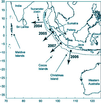
Figure 1 - Map of the eastern Indian Ocean
showing the location of: the earthquake epicentres (‘star’) and
direction of the primary wave propagation for the 2004, 2005,
2006 and 2007 tsunamis; Real-time sea level measurement stations
at Padang, Cocos Islands, Christmas Island and the deep water
tsunameter. The plate boundary is shown by the dashed line and
area of rupture for the 2004 tsunami is shown by the grey line. |
|
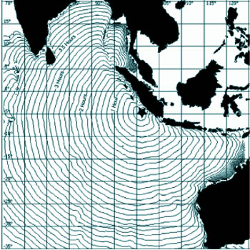
Figure 2 - A plot of isochrons (lines of equal time) of tsunami
propagation as a result of the 12 September 2007 earthquake off
Sumatra. The contour lines are in 10 min intervals. |
THE INDIAN OCEAN experienced its most devastating natural disaster
through the action of a tsunami, resulting from of an earthquake off the
coast of Sumatra on December 26, 2004. This resulted in widespread
damage both to property and human lives with over 250,000 deaths in the
region and many millions made homeless.
As a result, the destructive nature of the tsunamis is now well-known
and the public interest and awareness in tsunamis has increased
markedly.
The ocean around Sri Lanka consists of a very narrow continental
shelf with the mean distance between the coast to the 200m depth contour
being 20 km - at some locations along the southern coast, this distance
is reduced to 5km off Mirissa.
The narrow continental shelf means that Sri Lanka is extremely
vulnerable to the action of tsunamis as the wave transformation from
deep to shallow water occurs over a shorter distance and there is a
negligible amount of energy dissipated over the continental shelf
region.
Also there are significant topographic features such as islands,
seamounts etc between Sri Lanka and the tsunami generation region. The
2004 event has been followed by annual occurrence of oceanwide tsunamis
(i.e. those which influence area far from the generation region) in
2005, 2006 and 2007 (Table 1).
As a consequence of the 2004 tsunami, the Indian Ocean Tsunami
Warning and Mitigation System (IOTWS) was established under the auspices
of the UNESCO’s Intergovernmental Oceanographic Commission (IOC).
The Intergovernmental Coordination Group for the Indian Ocean Tsunami
Warning and Mitigation System (ICG/IOTWS) which includes representatives
from all of the Indian Ocean rim countries serves as the regional body
to plan and coordinate the design and implementation of an effective and
durable tsunami warning and mitigation system.
The overall objective of the IOTWS is to efficiently identify and
effectively mitigate the hazards posed by local and distant tsunamis.
To achieve this objective, an end-to-end tsunami warning system is
being developed that includes hazard detection and forecast, threat
evaluation and alert formulation, alert dissemination of public safety
messages, and preparedness and response.
Here, working of a tsunami warning system is described with reference
to the tsunami generated by a sub-sea earthquake off the coast of
Sumatra on 12th September 2007.
Tsunami generation: Background
Tsunamis are generated by a sudden movement of the sea floor which in
turn changes the sea surface level and the process of the sea level
returning to its equilibrium state generates waves which propagate away
from the generation.
The most common analogy is the effect of dropping a small pebble on a
pond where small waves propagate away from point of contact of the
pebble with the water surface.
The sudden movement of the sea floor is usually caused by (1) sub-sea
earthquake; (2) underwater volcanic eruption: or a sub-sea landslide,
which could be generated by an earthquake.
The Krakatoa eruption in 1883 is an example of a tsunami generated by
a volcanic eruption which impacted Sri Lanka and caused a single
causality. The Papua New Guinea tsunami on July 17, 1998 was generated
by a magnitude 7.0 sub-sea earthquake causing 2,100 deaths.
The highest recorded tsunami wave of 525m which occurred on July 9,
1958 in Lituya Bay, Alaska was caused by a landslide triggered by a
large, 8.3 magnitude earthquake.
Tsunamis which may impact Sri Lanka are generated by sub-sea
earthquakes off the coast of Indonesia and therefore the discussion is
limited to tsunamis generated by sub-sea earthquakes along the
continental plate boundary located offshore Indonesia (Figure 1). An
ocean-basin tsunami has been generated due to earthquakes along this
plate boundary in 2004, 2005, 2006 and 2007 (Table 1) and all of these
tsunamis have been recorded in a sea level gauges in Sri Lanka except
the 2006 tsunami off Java (Figure 1).
For a tsunami to be generated by a sub-sea earthquake, the movement
of the sea bed resulting from the earthquake should be sufficient to
disturb the sea surface. This is controlled by (1) magnitude of the
earthquake i.e. Richter Scale: (2) the focal depth - depth of the
earthquake epicentre below the sea surface; and, (3) the area of the sea
bed disturbance - for the 2004 tsunami resulted from an area of
1000kmx250km. Only the magnitude and depth information is available
immediately (i.e. 5-10 minutes) after the earthquake and thus the first
assessment whether a tsunami is generated has to be based to these two
parameters.
Analysis of historical earthquakes has revealed that tsunamis are
generated only by earthquakes exceeding 6.5 on the Richter scale with a
focal depth less than 50 kilometers beneath the seafloor. The main
energy of the tsunami is usually directed perpendicular to the plate
boundary or fault line.
Tsunami Warning System
At present, tsunami warnings for the Indian Ocean are issued by the
Pacific Tsunami Warning Centre (PTWC) located in Hawaii, USA who has
been providing tsunami warnings to the countries in the Pacific Ocean
rim for more than 40 years.
The warning is transmitted to focal points established in each IOTWS
participating country. In Sri Lanka, the Department of Meteorology is
the nominated focal point for receiving tsunami warnings.
As a result of planning initiated by the different working groups of
ICG/IOTWS, a network of real-time seismic and sea level stations have
been established across the Indian Ocean.
|
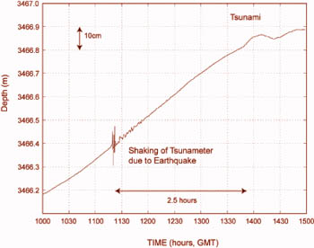
Figure 3 - Time series record from the Tsunameter showing the
initial bottom disturbance and the arrival of the tsunami 2.5
hours later. |
|
Figure 4 - Model output from ComMIT model for the region around
Sri Lanka for the 12 September earthquake. |
These instruments transmit data through satellites in real-time to
shore stations. The seismic stations facilitate the identification of
the location and magnitude of earthquakes whilst the sea level stations
will indicate whether a tsunami has been generated and also its
magnitude (wave height).
The PTWC system function begins with the occurrence of an earthquake
of sufficient size to alert the duty personnel at PTWC - the threshold
is set a magnitude above 5.5 Richter Scale.
At this time, the earthquake’s exact magnitude, focal depth, and
origin time are determined. If the earthquake is within or near the
Indian Ocean basin and its magnitude is higher than 6.5, but less than
or equal to 7.0 then a Tsunami Information Bulletin is issued to the
IOTWS focal points informing them that there is no threat of a
widespread tsunami, but in some cases a local tsunami may occur.
A similar bulletin is issued if the earthquake is of a larger
magnitude but is deep within the earth (i.e. high focal depth) or is
located clearly on land. A Local Tsunami Watch is issued to IOTWS focal
points for earthquakes of magnitude 7.1 to 7.5 and a Regional Tsunami
Watch is issued for magnitudes 7.6 to 7.8.
The Local or Regional Tsunami Watch is an alert to the possibility
that a destructive local or regional tsunami may have been generated
that could affect coasts located within several hundred to 1000km of the
epicentre. An Ocean-wide Tsunami Watch is issued for earthquakes of
magnitude 7.9 and greater.
The tsunami Watch bulletins are usually accompanied by prediction of
tsunami arrival times for geographic areas defined by the distance the
tsunami could travel in a subsequent time period (Figure 2). Tsunami
travel times can be calculated as the speed of propagation depends only
on the local water depth.
Subsequently the sea level recorders are monitored to determine
whether a tsunami has been generated and its magnitude. Computer models
results are also used to support the tsunami predictions. This
information is routinely transmitted to the IOTWS focal points until the
Watch is cancelled.
The Tsunami of September 12
An earthquake of initial magnitude 7.9 (later updated to 8.4)
occurred at 11:10 GMT off Southern Sumatra with a focal depth of 34 km.
Based on the criteria described above, an Ocean-wide Tsunami Watch was
issued for the Indian Ocean by PTWC.
Based on computer modelling of travel times (Figure 2) the tsunami
was predicted to reach the south-west coast of Sri Lanka at 14:40 GMT (3
hours 52min after the event); Trincomalee at 15:02GMT (3 hours 52min),
Colombo at 15:15GMT (4 hours 5min) and Jaffna at 16:25GMT (5 hours 15
min).
This relatively long tsunami propagation times to Sri Lanka enabled
the monitoring of sea level gages where the tsunami was predicted to
have an impact before reaching Sri Lanka as well as undertaking computer
modelling to predict the effect on Sri Lanka.
There were several sea level recording stations which were
operational and information on the tsunami generated: they included the
coastal sea level gages located at Padang (Indonesia), Cocos Island
(Australia) and Christmas Island (Australia). A deep water tsunameter
(previously called DART buoys) was also available.
The locations of these stations are shown on Figure 1 and the
characteristics of the tsunami incident on each of these locations are
provided on Table 2.
The first evidence that a tsunami was generated by the earthquake is
revealed in the tide gage at Padang (Figure 1) where a wave of initial
amplitude 0.35 m was recorded, 44 minutes after the earthquake.
Records at both Cocos and Christmas Island also indicated evidence of
the tsunami with initial heights 0.10m recorded 69 and 78 minutes after
the tsunami, respectively.
The tsunameter is an instrument specifically developed for monitoring
tsunamis in the deep ocean. Tsunameter 23401 was deployed in 2006
through cooperation between Thailand and the USA but is ideally placed
for tsunami warning for Sri Lanka as it lies between the tsunami
generation region and Sri Lanka (Figure 1).
Depending on the location of the earthquake the tsunami will be
recorded on the tsunameter 60 to 90 minutes before impacting Sri Lankan
coast. The instrument is located in 3500m water depth and includes a
bottom pressure sensor which measures the sea level to a very high
accuracy (order of 1 mm).
The bottom sensor transmits the sea level data to a surface buoy
which in turn transmit the data via satellite to NOAA’s National Data
Buoy Centre (USA).
The bottom instrument is programmed to transmit data at 15 minute
intervals but when the sensor detects an earthquake (due to shaking of
the sea bed)- it automatically transmits data at 1 min intervals. The
tsunameter record for the 12 September event shows the initial
disturbance due to the earthquake and the subsequent tsunami (Figure 3)
with only a very small tsunami (0.05m).
The real-time sea level recorders at Colombo, Trincomalee and Kirinda,
operated and maintained by the National Aquatic Research and Development
Agency (NARA) all recorded the tsunami with maximum wave heights of 0.6m
(Table 2).
The relatively long time lag between the earthquake and the tsunami
propagation to Sri Lanka also enabled computer models to be used to
predict the tsunami impact on Sri Lanka. A computer tool developed by
NOAA through funding provided by USAID as part of IOTWS named ComMIT
(Community Model for Tsunami Inundation) was used.
The principle of model operation is that a series of hypothetical
earthquakes located along the Sunda plate boundary (Figure 1) with
different magnitudes have been simulated and the results are stored in a
web server in Seattle.
Simulation a single Indian Ocean wide tsunami requires large
computing resources - several hours on a supercomputer and thus the
scenarios have been pre-computed and stored.
However, using the pre-computer data a single model run for a
selected region at high resolution can be undertaken in about 20 minutes
on a normal PC. The results of such a simulation, undertaken immediately
after the earthquake revealed a predicted initial tsunami height of 0.20
m incident on the south-west coast of Sri Lanka.
The results from the sea level recorders and computer models resulted
in the conclusion that a significant tsunami was unlikely to impact on
Sri Lanka for this event and the tsunami warning was cancelled.
It should be noted that a second earthquake with a magnitude of 7.9
and a focal depth of 30km occurred in the same region on 12 September
2007 at 23:49 GMT i.e. some 12 hours later. This earthquake also
generated a small tsunami with height 0.10m and was recorded in Cocos
and Christmas Island guages as well as in Colombo.
The writer is Professor of Coastal Oceanography, The University of
Western Australia
Email: [email protected]
Table 1 - Details of Indian Ocean Tsunamis 2004-2007

Year	Date	Magnitude of	Epicenter	Maximum
		Earthquake	Location	Tsunami
				Height in
				Sri Lanka

2004	26 Dec	  9.2		3.32 N		10.1 m
				95.854 E	Hambantota
2005	28 Mar	  8.6		2.07 N		2.7 m
				97.01 E		Kirinda
2006	17 July	  7.7		9.22 S		0.0 m
				107.32 E
2007	12 Sept	   8.4		4.52 N		0.6 m
				101.37 E	Trincomalee


TABLE 2 - Characteritsitcs of the 12 September 2007 Indian Ocean Tsunami

Sea Level 	Arrival Time 	Initial wave	Maximum Wave
Station		GMT		height		height

Padang		11:54		0.35 m		2.27 m
Christmas
Island		12:19		0.10 m		0.15 m
Cocos Island	12:28		0.11 m		0.24 m
Tsunameter
23401		13:47		0.05 m		0.046 m
Trincomalee	14:58		N/A		0.60 m
Colombo 15:12 0.3 m 0.60 m |