Little known corners
of Sri Lanka
The Wee - We Oya
W. J. Samuel
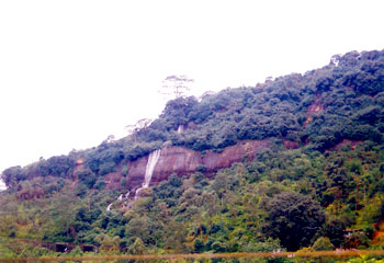
START OF A JOURNEY: The Diyatiri fall (30 m, 99 ft.) The
starting point of the Maha Oya waters flowing from the North
West flank of the Sentry Box East. |
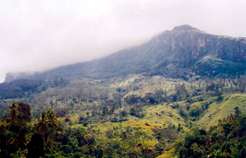
SPECTACULAR: The Kabaragala Range overlooking the town of
Nawalapitiya |
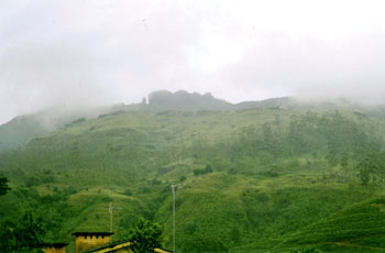
SILENT SENTINEL: The Sentry Box East (4721 ft) of the Dolosbage
valley |
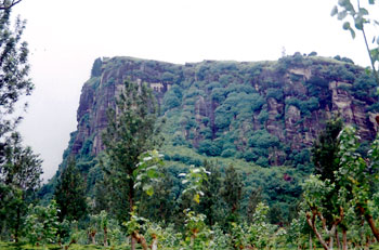
Kabaragala (4906 ft) overlooking Nawalapitiya. |
A nosy Parker cornered me the other day and wanted to know if I had
cornered anyone in the little known corners of Sri Lanka. I assured this
busy body that I have now turned over a new leaf and was proceeding
steadily along the straight and narrow way.
He was rather sceptical of my 'leafy conversion' and offered to
accompany me on my future geographical meanderings - just to have an eye
on things, in case I fall by the wayside again. I treated this offer
with the contempt it deserved.
The road from Yatiyantota along the We Oya is narrow but certainly
not straight. At Parusella junction on the road to Bulathkohupitiya (4
km) from Yatiyantota you turn right and take the long and winding road
to Punugala, Berannawa, Halgolle, Sea Forth Colony and back of beyond
ending up at Rambukpitiya on the main Nawalapitiya/Ginigathena main
highway.
I first heard of this road from my father who was a dispenser on
Ederapolla group Bulathkohupitiya for many years.
He revealed that R. J. S. Bean, who was then Manager of Ederapolla,
and a well-known visiting agent used to take this steep road on his
errant drives to nab errant 'estate johnnys' in the Nawalapitiya region.
Mr. Bean, a large, florid New Zealander was one of those who polished
off large helpings of food. My brother-in-law, who also worked under him
for many years, told me with amazement how Mr. Bean polished off a
succulent sucking in one sitting!
The next morning Mr. Bean looked at my brother-in-law sadly and said,
"Sada, it was only eight pounds!" Tapping a kangany in the 'piggy
business', my brother-in-law was able to procure a larger sized 'porky',
which kept Mr. Bean purring contentedly in office for the next few days.
Some jealous folk in the Kelani Valley area spread a vicious rumour
that the pig was the 'stepping stone' for my brother-in-law's rapid
promotions on Ederapolla (he later became Manager and thereafter a
Director of J.E.D.B.). The real reason of course was that Mr. Bean,
despite being a hard taskmaster, was one who appreciated hard work and
rewarded hard workers.
Mr. Bean was the father of that well-known ruggerite Chris Bean who I
believe represented the island at Rugby. They were no relations of the
British TV Comedian who makes funny faces.
The We Oya trickles down from the area west of Dolosbage in the
Meenagalla, Miyanagolla, Windsor Forest Region, which is situated at an
elevation of around 3500 ft.
This area is about 1 1/2 miles as the crow flies, north west of a
little known mountain called Sentry Box East (4721 ft).
The waters from the northeastern slopes of this mountain range flow
into the Maha Oya. Therefore this mountain range is the watershed line
or the dividing line between two river basins:
We Oya - North West Slopes
Maha Oya - North East Slopes.
A watershed is a line of high land where streams on one side flow
into one river and streams on the other side flow into another.
It could also mean a turning point in the course of event.
This line of high land from Sentry Box East (4721 ft) proceeds along
a ridge running in a north westerly course pass an abandoned estate
called PEN-Y-LAN, Kellie group, Ambalakanda Narangalle group,
Rameserakapella 3667 ft. Debatgama group towards ORAKANDE 2500 ft. where
Minister Ashroff met a tragic death in a helicopter crash.
Motorists driving from Colombo to Kandy can spot this mountain
easily. It can be viewed from the bend near the Kadugannawa road tunnel.
It is the rounded mountain to the right of Bible Rock (Batalegala 2618
ft).
Batalegala (Bible Rock 2618 ft) Orakande 2500 ft.
Let us get back to the We Oya Valley near Dolosbage as we have
deviated and digressed.
There is an interesting observation made by Dr. Eberhard Kautszch of
Germany in his book titled "A guide to the waterfalls of Sri Lanka. In
page 57 - No. 70 Kelvin Fall - the author states that the river bed of
the We Oya, near Kelvin water fall is 150m (approximately) 500 ft lower
than the bed of the Ritigala Oya Valley which is a parallel river
flowing a few miles to the north.
In the same book Dr. Kautzch describes the following roadride
beauties - waterfalls.
Page 56 - No. 69 Windsor in forest Fall 10 m 2 Km Dolosbage
57 - No. 70 Kelvin Fall 5 Km - Dolosbage
58 - No. 72 We Oya Fall 20m Malalpola - 13 Km
58 - No. 73 Kitul Falls 15 m Malalpola 13 Km
58 Olu Falls - Malalpola 200 m 13 Km
The Olu Falls is the fiftieth highest waterfall in Sri Lanka.
We in Sri Lanka are going through a difficult period.
There is no reason why we should feel despondent. So, shall we pack
up our troubles in an old kit bag and smile, smile, smile.
I referred to Sentry Box East (4721 ft) earlier as a little known
mountain. It certainly is, as to view it one has to deviate and make a
special trip to Dolosbage from Nawalapitiya. It could be described as a
'coy' mountain bashfully, behind it more prominent partner Rabanagala
(4942 ft), which towers over the town of Nawalapitiya.
Shall we then trickle this mountain and have a little fun.
"Oh, silent sentinel of the Dolosbage Valley, speak and reveal to us
your hidden secrets."
Did you see the Kandyan 'Rolling Stones' group perform from the
Balane heights? Were they large stones that they hurdled at our
invaders?
You must have seen slippery Saradiel's sallys and sorties from
Utuwankanda. Did the really rob the rich and give the poor? Or did he
rob the poor and give the rich?
Was some of his loot looted by the wily Hetties of Hettimulla?
On that hilarious note, I shall leave you and vanish. In case that
'nosy parker' buttonholes me again.
|


