|
 |
| Monday, 3 January 2005 |
 |
|
| Features |
| News Business Features Editorial Security Politics World Letters Sports Obituaries
|
Earthquakes, Tsunamis - some questions and answers by Dr. Kapila Dahanayake Senior Professor of Geology, University of Peradeniya. Of the millions of earthquakes which shake our planet in a given year, the smallest pass unnoticed, whilst the largest are felt over hundreds of thousands of square kilometers. One of the most frightening and destructive phenomena of nature that man experiences is a severe earthquake and its terrible after-effects.
Since long before man existed, probably for more than 4 billion years, the forces within the Earth that produce earthquakes have played an active role in shaping the Earth's surface. These unpredictable catastrophic events affecting the surface of the Earth and resulting from little understood forces deep within its interior cause a great number of human casualties and immense damage to property. Hazards associated with earthquakes include the phenomena of ground shaking, surface faulting, earthquake induced ground failures and tsunamis. Earthquakes and associated tsunamis have the potential for causing great sudden loss. Within a few minutes, an earthquake can impact part or all of a city or countries through ground shaking. A tsunami can also be generated in some earthquakes and impact local and distant coastal communities some thousands of kilometers away. Earthquakes - how do they occur? An earthquake - the sudden oscillatory and sometimes violent motion or trembling in the Earth is caused by an abrupt release of energy in the earth's crust. This energy can be released by a sudden dislocation of segments of the crust, by a volcanic eruption or even by man made explosions.
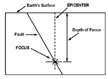
The earthquakes vary in size from minor tremors that are perceptible only to sensitive instruments to a few great earthquakes that cause considerable loss of life and property. The theory of plate tectonics can explain the occurrence of earthquakes. According to this theory, Earth has been broken into several rigid (solid) major plates - 12 or 13 of them - that move together and apart like pieces of a jigsaw puzzle. - They are designated as North American, Pacific, South American, Antarctic, African, Eurasian, African, Arabian, E Asia, Nazca, Scotia, Indian Australian plates. Indian Australian plate -long identified as a single plate appears to have broken apart just south of equator beneath the Indian Ocean forming the 13th plate. The plates can be between 50 to 100km thick rigid plates or segments of the Earth's crust and the upper mantle (A cross section of the 6371km radius of the earth would show an upper crust overlying the mantle, which floats over the outer core. This core overlies the inner core of the interior of the earth - see Figure 1 below). The plates move slowly and continuously over the interior of the earth meeting in some areas and separating in others. Velocities of relative motion between adjacent plates range from about 1cm to 12 cm per year. As the plates move strain accumulates and eventually slippage can occur near plate boundaries causing a fault. Fault, Focus and Epicenter of an earthquake A fault is a fracture in the earth's crust along which two blocks of the crust have slipped with respect to each other. One plate or block can slip or move with respect to the other horizontally or vertically causing a rupture of the earth's crust. The fault rupture begins at the FOCUS of the earthquake and the first seismic waves originate here. The EPICENTER is the point on the earth's surface directly above the FOCUS. The focal depth of an earthquake is the depth from the Earth's surface to the focus where an earthquake's energy originates. Earthquakes with focal depths of 60km or less are classified as shallow. Those with focal depths from 60 to 300 km are classified as intermediate or deep the earthquakes tend to recur along faults in plate margins, which reflect zones of weakness in the Earth's crust. The fact that a fault zone has recently experienced an earthquake offers no assurance that enough stress has been relieved to prevent another quake. Seismic Waves and Measurement of Earthquakes What is Richter Scale? The two general types of vibrations caused by earthquakes are surface waves, which travel along the earth's surface and body waves, which travel through the earth. These seismic waves which propagate at speeds of more than 15,000 km per hour cause extensive damage to buildings. They are detected, recorded and measured by instruments called seismometers, which can sense earth motion. A seismograph combines a seismometer with recording equipment, which provides a permanent continuous record of the motion, and the record itself is called a seismogram. Seismogram is a zigzag line made by a seismograph, which will provide information needed to determine epicenter, depth of focus, magnitude and estimates about energy released. The magnitude is related to the amount of seismic energy released at the focus of the earthquake. To fix the epicenter, readings from at least three observatories are needed. The Richter Scale developed in 1935 by Dr Charles F Richter of California Institute of Technology is the best-known scale for measuring the magnitude of earthquakes. The magnitude scale has neither minimum nor maximum values, the highest magnitude ever calculated was greater than 9. It is a mathematical device to compare the size of earthquakes. The magnitude of an earthquake is determined from the logarithm of waves recorded by seismographs. Adjustments are included in the magnitude formula to compensate for the variation in the distance between various seismographs and the epicenter of the earthquakes. On the Richter scale, the magnitude M of the earthquake is generally expressed as M=log (A/T) where M-magnitude, A- maximum amplitude of ground motion in microns T- dominant wave period in seconds Various types of magnitude (Surface Wave, Body Wave, Local etc.,) are computed by various institutions and the Surface wave magnitude (Ms) for shallow earthquakes calculated by the USGS is as follows and is considered to be more reliable. Ms=log(A/T)+1.66 log D + 3.3 Where A - maximum ground amplitude in microns of the vertical component of the surface wave within the period range 18<= T <= 22; T- period in seconds and D - distance in geocentric degrees (station to epicenter) and 20 degrees <=D <=160 degrees On the Richter scale, the magnitude of the earthquake is expressed in whole numbers and decimal fractions. For example, a magnitude of 5.3 might be computed for a moderate earthquake and 6.3 for a strong one. Because of the logarithmic basis of the scale, each whole number increase in magnitude represents a 10-fold increase in measured amplitude. As an estimate of energy, each whole number step in the magnitude scale corresponds to a release of about 31 times more energy than the amount associated with the preceding whole number. Earthquakes of 2 or less are called micro earthquakes. Those with magnitudes of 4.5 or greater are strong enough to be recorded by sensitive seismographs all over the world. Those having magnitudes of 8 or above are great earthquakes. Tsunamis -What causes them? Their Characteristics Tsunamis (a Japanese word meaning harbour waves) are systems of ocean gravity waves that are caused by sudden vertical movement of a large area of sea floor during an undersea earthquake. A vertical disruption of the water column can result from such a vertical tectonic displacement of the sea bottom along a zone of fracture in the earth's crust. In a very large tsunamigenic earthquake like the 26/12 event, 100,000 sq km or more of the sea floor may have got displaced up to several meters. Tsunamis and associated earthquake ground shaking differ in their destructive characteristics. Ground shaking causes destruction in the vicinity of the fault (e.g near Sumatra in the 26/12 event) whereas the tsunamis can cause destruction locally and at very distant locations (e.g Somalia). Other triggering mechanisms of tsunamis include volcanic eruptions in the ocean, displacement of submarine sediments, coastal landslides or even large scale man-made detonations or meteor impacts. Tsunamis are often called Tidal Waves but this term is a misnomer. Unlike regular ocean tides, tsunamis are not caused by the tidal action of the Moon and Sun. A tsunami travels outwards from the epicenter of a tsunamigenic earthquake (with magnitudes generally over 6.5 on the Richter Scale) as a series of waves. Its height in the deep ocean is typically about 30cm but the distance between wave crests can be very long-more than 75km Its speed depends on the depth of water and increasing/decreasing ocean depth. In areas of oceans where the water depths reach more than 3km the tsunami speeds travels at speeds of 500 to 1000km per hour. The speed of a tsunami decreases as water depth decreases As they reach shallow water around islands or on a continental shelf, the height of the wave can increase many times, sometimes reaching levels of more than 25m.Near shore, a tsunami will slow down its speed to just a few tens of kilometers per hour. At the shore, the tsunami will behave differently depending on the near shore bathymetry, shape of the coastline and the state of the tide. In some instances, a tsunami may induce relatively benign flooding particularly in low-lying coastal areas. In other instances, it can come onshore as a vertical wall of turbulent water that can be very destructive. In most cases there can be a draw down of sea level either preceding or in between crests of tsunami waves that results in a receding of the shoreline, sometimes by a kilometer or more. Destruction from tsunamis is the direct result of three factors: inundation, wave impact on structures and erosion. Strong tsunami-induced currents have led to the erosion of foundations, collapse of bridges and sea walls. Floatation and drag forces can move houses and overturn vehicles including moving trains. The floating debris including boats and cars can become dangerous projectiles and cause considerable damage The disastrous 26/12 event was a shallow earthquake with its focus at a depth of about 10km below the earth's surface and characterized by vertical motion causing the slip of about 1000km of the plate boundary. It took place on 26th December 2004 at about 7.00 a.m (Sri Lanka time) in a seismically active region at the plate boundary separating Indian-Australian and E Asia plates. The epicenter was located on the seabed off the west coast of northern Sumatra island. It is the fifth most powerful in the world in the last 100 years registering a magnitude of 9.0 on the Richter Scale and the worst in 40 years causing more than 1,25000 human casualties in 12 countries of the region. A 9.2 strong earthquake hit Alaska in 1964. The damages were caused by earth shaking that happens in any earthquake (e.g in regions close to the epicenter of the earthquake like Sumatra) and seismic sea waves (tsunamis- or tidal waves) that originated with this tsunamigenic earthquake and struck coastal regions causing unprecedented destruction to life and property in the Indian ocean region where such events were rare. Only five tsunamis had been reported in the last 500 years. The 26/12/2004 tsunamigenic earthquake with 125000 human casualties has taken the biggest human toll recorded so far in the world by any tsunami. The earlier high casualty tsunami was reported from Chile in 1868 with 25000 deaths. |
|
News | Business | Features
| Editorial | Security
Produced by Lake House |