|
 |
| Friday, 27 September 2002 |
 |
|
| Features |
| News Business Features Editorial Security Politics World Letters Sports Obituaries
|
Parts of the Dry Zone on the threshold of desertification by Dr. M. U. A. Tennakoon
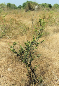
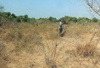
Desertification of a land takes place in several phases over a long period of time; over centuries if slow and over many decades if accelerated. The first phase commences when a luxuriant vegetation begins to suffer either due to a climatic change for worse or man's reckless interference with nature in forest destruction. Thinning tree canopy density due to the destruction of trees here and there allows penetration of scorching rays of the sun through the canopyless spaces increasing the drying of ground beneath. It then gets into the second phase of desertification with increased forest destruction by loggers, chena cultivation and 'land developers'. Where the tree density is further thinned by them, more sunlight is allowed to reach ground, drying the once sheltered surface soil. Due to the thinning of trees, the lust of trees to compete to rise above one another declines, with increasing tendency to widen the perimeters of individual tree canopies, in the canopy covered space which is more open now than during the first phase. Trees begin to remain dwarfed. On the ground more land spaces begin to lose soil moisture faster than in the first phase. It is in this phase, that, thorny plants and trees begin to rise up to withstand the increasing surface dryness. In the third phase, where there is a further destruction of trees, the surviving trees begin to be further dwarfed and have wide tree canopies. By this phase, atmospheric and ground moisture being quickly reduced and the drying winds becoming stronger than before, allowing only the dwarfed, wide-buttressed, stocky-trunked trees to survive. Widening exposure of the ground surface, devoid of heavily-canopied trees, allows a powerful undergrowth of tangled, thorny and almost impenetrable brush-woods. In this third stage, about 75 per cent of surviving plants and trees become thorny capable of withstanding a very harsh dry climatic environment. In the common parlance of villages this vegetation is "bootewa".
Even the same tree species have different forms in the above three phases, with remarkable adaptation to the three different environments. Palu tree (Manilkara hexandra) in phase one, is very tall, lighter in bark colour (near ash colour), low in leaf density, thin in twig density and have a tendency to struggle to grow upwards with a restricted canopy perimeter. During the second phase the same tree, has a reduced height, bark moderately dark in colour, intermediate leaf density, increased twig-density less inclined to grow tall but to widen the canopy out-reach. The same tree species in the third phase of desertification appeared dwarfed, dark in bark colour, bark closely and heavily cracked, kinky leaves with high twig density with low and wide canopy out-reach highly resistant to wind and weather-beating. Its wood is very hard and strong. It is because of the tough appearance of this Tree in the third phase of desertification, that the villagers call it kaaberi palu. Phase four is virtually the threshold of desertification, where even the very tough thorny brush-woods are forced to wither leaving behind only a handful of hardy thorny plants such as "Kukulkalu" (Madras Thorns), "Andara, Seeniya" and "Keeriya" and an extremely few varieties of drought resistant plants such as 'thillan' and cactus capable of storing water in their systems during the rainy season to draw upon requisite moisture from their own storage to survive through long drought periods of 6 to 8 months. During the latter stages of the fourth place, even some of these hardy thorny plants wither and dry off leaving only very small clusters of impoverished thorny plants struggling to stay on the ground. Very large spaces of base soil with only a sprinkle of withering tough grasses become ideal surfaces for wind erosion during the dry seasons and sheet erosion during the rainy reasons. The third and fourth phases in particular have other dire consequences, in addition to the change of micro-climate for worse by accelerating acidity destroying the total vegetation over the whole process from phase one through to phase four. That is accelerated soil erosion in higher grounds with the rains taking eroded materials in solution and suspension in water to deposit them in water bodies, notably in irrigation tanks. Siltation reduces water storage capacity in reservoirs and dry them by the middle or even by the early part of 6 to 8 month long rainless dry period of the year. This early water shortage during the dry season further accelerates the ruination of natural and man-made vegetation. During August 2002, in four selected village tanks (Galkadawala, Messalewa, Kona Kumbukwewa and Kapiriggama) in the Kapiriggama cascade in the Rambewa Divisional Secretariat area, an attempt was made to ascertain the thickness of the silt loads. In each tank six pits were dug upto the impervious soil bed strata and the results obtained are now being used to estimate the silt loads for which data on water spread areas and the depths of water held in these tanks are necessary. Excavations recently concluded in the above four tank beds shows that the silt loads measured (and photographed) show that: (a) the depth of silt loads from the inner toes of the tank bunds towards the upper shore-lines of the tank vary from 3 1/2 feet to six inches along cross-sectional measurements of 1,000 to 1,200 feet; (b) and half-way between the inner toe of the tank bund to the uppershore line of a tank the thickness of this silt load is about 1 1/2 feet. This shows that 'dead storage' parts of the tanks have the largest part of the silt load deposited. In one situation, (that is in the Kallanchiya tank downstream of the Kapiriggama tank referred to) at the mid-point of the 'dead storage' the depth of water in 1950 was 18 feet when the water is at the spilling level. The depth of the silt load at the same point measured in August 2001 was 10 feet, leaving only 8 feet of water when this tank is filled to capacity. Assuming that the same process of silt accumulation takes place, it can be projected to see, that, in 40 years from now (i.e. in the year 2040) this tank will hold no water at all and it would appear as a desert! The Dry Zone hydraulic civilisation is at the brink of severe disaster with desertification looming large because of the unabated silt accumulation accelerated by vegetation deterioration and increased surface soil erosion. Productivity of land either remains plateaued or on the decline because of unchecked soil erosion. Silt accumulation in large irrigation reservoirs (Kotmale, Rantambe, Victoria, Polgolla barrage etc.) has caused concern to many authorities but the same disaster looming over 16,000 small tanks appears to have fallen on deaf ears. Without production contributions from farmlands irrigated by small tanks, this country will never be able to ensure food security to the whole nation. We have been dodging this critical issue over the past 40 years. If the same attitude continues the great North Central plain will be a desert by the end of the next 40 years. It can happen even earlier! At present, the western half of the Anuradhapura district (Wilachchiya, Rambawewa, Nuwargampalatha West, Rambawewa and Medawachchiya Divisional Secretariat Divisions) shows the most advanced phases - third and fourth phases - of desertification. In Australia what the Australians call the Mallee Desert along the border of South Australia and Victoria, has a vegetation similar to or better than that in the above mentioned Divisional Secretariat Divisions, and more so in the Wilachchiya Divisional Secretariat. In addition to ample photographic evidence available in respect of the on-going desertification process, there are increasing biological clues of the impending desertification. It is observed over the past 20 years that; (a) some plants indigenous to the Rajarata have disappeared or on the verge of extinction (binkohomba and lee kola), (b) some snakes (kunakatua) commonly found in the Western half the Anuradhapura district have already disappeared (c) In many places the percentage of many plants in the vegetation in the 1970s, which was in the region of 20-25 has now increased to about 70; (d) there are more frequent minor droughts each year somewhere in the Rajarata in addition to the regionally and nationally significant droughts; and (e) the most recent and exciting evidence is the increasing appearance of peacocks even in the central parts of the Rajarata where brushwoods' or still poor vegetation is now dominant. Peacock is a heavy lazy land-bound bird unwilling to fly except for the fear of death or on to a low safe branch of a low tree for the night rest. It desires to move on the ground eating bush-berries, nuts, seeds and insects which can be located in its neck-high bushes, small plants and on the ground. Peacock cannot survive in dense forests for its inability to reach twig-ends of tall trees to pick fruits, nuts etc. for food. Fifty years ago, it was even hard to sight peacocks even in the driest parts of the Wilpattu sanctuary. But today, peacocks have migrated as far as interior Galenbindunuwewa and Kekirawa because in many parts of these environs the vegetation is in the third and fourth phases of desertification which form the ideal haunts and breeding grounds for these 'desert-margin' birds. Reforestation and arresting silting of reservoirs, these are of paramount importance in any attempt to save the North Cental Dry Zone from the peril of desertification. These two have to be put on a war footing to save the Dry Zone. Reforestation has to be viewed not only as a device to improve vegetation and thereby increasing water resources and micro-climate. It has to be viewed as a source of wealth creation. Supposing we have planted 80 million trees in the Rajarata in 1980, today, at the rate of Rs. 5,000 per tree the income of the Rajarata would have been Rs. 400,000 million. The longer we ignore arresting siltation in the Rajarata, the faster the completion of desertification in it. Those who are against desiltation advocate that (a) it is too costly an operation and (b) that there is no place to deposit the silt removed. The first argument has been amply defeated in a few studies made in the recent past. There are many ways of meeting the second argument advocated against tank desilting. One way is to compact silt on the tank bunds after widening the existing bund towards their outer toes and inner toes. For centuries this has been done so, using manual labour under the system of "Kattikepeema" - a beneficial remnant of the Rajakariya system, most activities of which, were abolished in 1832. "Kattikepeema" lost its way during the mid twentieth century. This needs revival after government assisted program of desilting is complete. Government intervention is necessary because the loads of silt accumulated over the past 40 years or so are too much to be removed in a year using manual labour. Once a complete silt removal with state intervention is done at least for the next fifty years such a costly desilting by the state would not be necessary provided that regular silt removal (annually) is legally re-introduced so, that, people themselves are compelled to engage themselves in the 'kattikepeema' system in their village tanks. If the present volumes of silt in tanks would exceed the need of tank bund construction/enlargement, then, the balance loads of silt can be helped up at several points of the upper, shore-lines of tanks. Here, there is a possibility of some 'anti-desilting persons' arguing that such heaps will be once again washed down to the tanks. There are many simple ways of permanent fixing of soil heaps. The same strategies used in fixing soil in steep road slopes, river banks etc. can be used in fixing heaps of silt removed from the tanks. Still another way is to encourage villagers to use silt in their gardens and highland farms to improve the existing compact soil texture with organic matter which abounds in tank silt. This silt, unlike the water thirsty reddish brown earth bases in those village gardens and highland farms, has a greater moisture retention capability. There is always a way, if there is a will. (This article was compiled while doing a field study on desertification in the Rajarata during early September, 2002) |
|
News | Business | Features
| Editorial | Security
Produced by Lake House |
 Desert and desertification should not be confused. Desertification is
the process of change from a prime forest status to a desert status with
extremely poor states of vegetation with a few hardy plants and thorny
bushes on largely surface soil or sand expanses. Desert is the final
product of the desertification process.
Desert and desertification should not be confused. Desertification is
the process of change from a prime forest status to a desert status with
extremely poor states of vegetation with a few hardy plants and thorny
bushes on largely surface soil or sand expanses. Desert is the final
product of the desertification process.